My article that describes last year’s SOTA/POTA/VHF contest activation from Pikes Peak appears in the June issue of QST magazine. This VHF/UHF activation occurred on the Saturday of the ARRL June VHF Contest and qualified for Summits On The Air (W0C/FR-004 Pikes Peak) and Parks On The Air (K-4404 Pike National Forest). The article highlights the use of the North America Adventure Frequency of 146.58 MHz.
I made 80 radio contacts that day, on the 6m, 2m, 1.25m, 70cm, and 23cm bands. Not a great score for the VHF contest but quite nice for a VHF SOTA and POTA activation. My primary piece of equipment was the ICOM IC-705, which enabled all modes on the main VHF/UHF frequencies.
If you are an ARRL member, look for the article on Page 58 of the print edition of June QST or the online version. Not an ARRL member? Darn, you should fix that if you want to read articles published in QST.
If you are an ARRL member, please look at the article and consider voting for it in the QST Cover Plaque Award. Thanks!
We were looking for a SOTA summit to activate near Salida, so I started to poke around using SOTLAS. There is still plenty of snow at the higher elevations, so we wanted to stay lower. SOTLAS has some useful filtering features that allow you to show only the summits of interest. Initially, I looked for a summit that Joyce/K0JJW and I had not yet activated.
Bob/K0NR and Joyce/K0JJW with SC-102 in the background.
Then I noticed that an unnamed summit (W0C/SC-102) had never been activated, not by anyone. When a summit has never been activated, it is often because it is really difficult to access or it is on private land. Using Gaiagps, my preferred mapping software, I checked out land ownership and the surrounding terrain.
A map of the area around SC-102, which is indicated as the 8380 waypoint.
The summit is on land managed by the Bureau of Land Management (BLM). The box labeled Sand Gulch is Colorado State land. This area is clearly on public land without any private property to deal with. We considered two routes to get to the summit. One option is to hike up from the west, which would probably work. But we noticed a 4WD road that approached from the north side that might provide better access. We weren’t sure how difficult the road would be to drive but we decided to give it a try. The road turned out to be easy 4WD, with just a few steep sections that might prove troublesome if the road were muddy. It presented no problem for our stock Jeep Wrangler. There were several side roads not shown on the map that could be a diversion, so having Gaiagps on my iPhone was helpful.
The red line is the 4WD road and the blue line is the hike to the summit.
The parking spot for the Jeep is shown on the map above. We were careful with the route finding for this summit, even though it is only a mile or so. We wanted to stay on top of the ridgeline and not get lost in one of the side drainages. Gaiagps on my phone recorded the hike as 1.1 miles one way with an elevation gain of 360 feet, so not very difficult.
The Jeep Wrangler parked at the “trailhead”.
The photo below shows the typical terrain as we hiked along the ridge. There was plenty of pinion pine and juniper, along with a surprising number of small cacti. Since the summit is unnamed, we decided to call it Cactus Ridge.
There is no established trail but the bushwacking is relatively easy. This photo shows the typical path with not-so-dense pine trees.
We made contacts mostly on 2m FM (146.52 MHz) using the 50-watt Yaesu FT-90 transceiver driving a 3-element Yagi antenna. I was curious to see how far we could work because the summit is not that high and sits roughly in the canyon of the Arkansas River, between Salida and Canon City. As expected, Salida stations (KD0VHD, K0LPR) were close by and easy to work. Stations in Buena Vista (KF0IHL, KD0MRC, W0BV) also came in quite strong. Our best DX for the day might be N0KM near Center, CO at a distance of 55 miles. But we also worked K0EEP, N0CFM, and KA0SDE camping somewhere near Jefferson, perhaps 60 miles or so, not sure exactly. Although they were due north of us, we had to point the Yagi antenna to the south to work them, apparently getting a nice reflection off one of the high peaks. Similarly, when we worked K0LTH in Guffey (to the north), we had to point the antenna south. We tried to work Amanda/K1DDN in Canon City but were unsuccessful. I thought we might be able to funnel a signal down the canyon to her with a few favorable reflections. No luck with that, but you never know until you try.
Thanks to everyone that listened for us and worked us!
The weather report was sketchy for the day but conditions were cloudy and warm (50 deg F) when we were on the summit at 11:30 AM. Later in the day, after we were back in Salida, we had rain and snow coming down. Springtime in the Rockies.
This was a very enjoyable summit, partially because it had the experience of exploring something new. The easy 4WD road was a pleasant surprise and made us wonder where the other roads in the area lead. At 8280 feet, this summit is only worth two SOTA points. But it’s not about the points, right?
Bob/K0NR operating from unnamed summit W0C/SP-094.
I do a lot of SOTA activating using 2m FM and have developed a few operating habits that can really make a difference. These may seem obvious but might be overlooked by operators new to the game. To get an overview of using VHF for SOTA, look at this article: How to Do A VHF SOTA Activation.
Here are three operating tips when using 2m FM for SOTA:
1. Upgrade Your Antenna
A handheld radio is commonly used for SOTA operation because it is a self-contained, compact radio. These radios always come with a rubber duck (electrically-short monopole) antenna. These antennas vary in quality but they are universally poor performers compared to a half-wave radiator. I’ve measured the effectiveness of many rubber duck antennas on 2 meters and they are somewhere between 8 and 12 dB worse than a half-wave radiator. So an easy upgrade is to use a half-wave telescoping antenna. Another popular option with a half-wave radiator is the roll-up J-pole (often called a “Slim Jim” antenna). An even better choice is a small 3-element Yagi such as the 146-3 from Arrow antenna, which is about 6 dB better than a halfwave antenna. Keep in mind that the Yagi should be held vertically-oriented for FM operating.
2. Open Your Squelch
The squelch circuit in an FM receiver requires the signal to be large enough to flip the squelch open. When operating at weak signal levels, the squelch may mask a signal that is actually readable. A recommended technique is to just open up the squelch control and let the FM noise come through. This maximizes the opportunity to pick out that weak signal out of the noise.
3. Point Your Antenna Everywhere
If you have a directional antenna, make sure you methodically point it in a variety of directions when calling CQ. For example, with a 3-element Yagi, you should divide up the 360 degrees around you into 45-degree sections. Point north, make a call, point northeast, make a call, point east, make a call, and so forth. Also be aware that the direct path to another station may not be the strongest path. This is especially true if you have tall summits around you that can block or reflect your signal. Many times I’ve pointed in the “right direction” to work another station but then found that the signals were strongest with the antenna pointed away from the direct path. So the secret is go ahead and try different antenna orientations to maximize the signal strength, even when you know the physical direction to the other station. Sometimes the radio waves decide to take another path.
Those are my three tips for today.
Do you have any to add?
Being an enthusiast for bands above 50 MHz, I suppose I should weigh in on the new IC-905 from Icom. The street price for the basic unit is ~$3500, with various options and accessories at additional cost.
Let’s be clear about one thing, this radio is one impressive piece of technology. There is no other radio on the market that comes close to covering these VHF/UHF/SHF bands: 144, 430, 1200, 2400, and 5600 MHz (and optional 10 GHz). I won’t mention all of the features and specs covered here. I really appreciate that Icom is investing in equipment for VHF and higher, as evidenced by the IC-9700 and this radio.
For me, there are two main uses I would consider for the IC-905: Summits On The Air (SOTA) and base station use:
SOTA
I focus on VHF/UHF for SOTA with 144 MHz always carrying the load in terms of making radio contacts. Lately, I have put more effort into 432 MHz and 1.2 GHz. I’ve also been trying to get out of the FM rut and work more SSB and CW on those bands. I really should get going on a portable digital station for FT8 and other modes. I have a good collection of gear to choose from, ranging from basic 5-watt FM handhelds to an IC-705 and an IC-9700. OK, the IC-9700 is a bit large to drag up most summits but I have taken it on some easy hikes and drive-up summits. Joyce/K0JJW and I also have a pair of Alinco triband handheld radios (DJ-G7T) that have 1.2 GHz FM. These radios are popular with SOTA enthusiasts due to their affordability and compact size.
What does the IC-905 offer for SOTA? Well, obviously it is a reasonable way to get on 5 or 6 bands with all modes. However, I already have the IC-705 that covers 144 and 432 MHz (and 50 MHz). Having CW/SSB on 1.2 GHz is very attractive to me but 2.4 GHz and 5.6 GHz are rarely used for SOTA. Sure, maybe the introduction of the IC-905 will change that. Maybe, but probably not. Someone commented in an online forum that you better buy two IC-905s and loan one out so you have someone to work. For my interests, I would much rather have a VHF/UHF-only variant of the IC-705 that covers the 50, 144, 440, and 1200 MHz bands. But I have come to accept the fact that radio manufacturers don’t develop radios just for me.
Base Station
The other option is to use the IC-905 to get on the higher bands from my home station. I am in the process of building a VHF+ station at our cabin in the mountains, which is in a good VHF/UHF location. Honestly, my focus is on getting a tower up with good size Yagi antennas for 50 MHz and 144 MHz. Although I have operated a lot on these bands, it has usually been from portable and rover stations, during one of the VHF contests, or as a SOTA activation. I am looking forward to having an effective permanent station on the two most popular VHF bands. I am debating how much effort to put into the 430 MHz and 1200 MHz bands at the new station, and 2400 and 5600 MHz are not currently in my plans. Besides, the IC-9700 has me covered for 144, 430, and 1200 MHz. So right now, I don’t see the IC-905 being part of the home station, but that could certainly change with time.
Price
What about the price? $3500 is a serious piece of change but probably not unreasonable for what this radio can do. Some people have said it is worth it and some think it is way too expensive. Price is always an issue, but for me it probably doesn’t matter that much. For the most part, I am saying the radio doesn’t fit a need I have. OK, if the price were a lot lower (like $1500), it would affect my point of view. But at that price, Icom would be leaving money on the table with the folks that really want to get on 2.4, 5.6 and 10 GHz.
So my conclusion is that I probably won’t be buying an IC-905 at this time, but things can always change.
Sometimes you just want a close-in SOTA summit that is easy to access and allows you to get on the air. On the west side of greater Denver, a few summits meet that requirement. One of them is Green Mountain (W0C/FR-107), near the intersection of I-70 and C-470. This would make a good beginner summit or an easy-access summit for visitors to the area. Joyce/K0JJW and I activated this 1-point summit today.
The blue line marks our route up Green Mountain, starting at the trailhead on South Rooney Road.
Access is easy and convenient, the trailhead can be found by going west on Alameda Parkway, off C-470, then north on S Rooney Road. There is a large parking lot there and an obvious trailhead with pit toilets. From here we hiked east over C-470 into William Frederick Hayden Park. We followed signs for the Green Mountain Trail, which is basically an unimproved road, to the summit of Green Mountain (see map above). This is not the only option because the park has an extensive trail system to explore. Check out the Lakewood parks map here. Also, you can check the trail conditions here. My mapping app recorded the hike as 1.6 miles (one way) with an elevation gain of 800 feet, not very difficult but still a decent hike. On a cool Saturday afternoon, we met many hikers and mountain bikers on the trail.
The view looking west from Green Mountain.
This hike starts out with a lot of road noise from C-470 but things soon quieted down as we left the highway behind. On the summit, we could see many higher summits to the west and downtown Denver to the east. We just had a couple of handheld VHF/UHF radios with us and made a bunch of contacts on 2m FM. This is usually the case when you have line-of-sight to the Denver area, with plenty of activity on 146.52 MHz.
This summit is not the best SOTA summit in the state but if you are itching to do a SOTA activation without driving deep into the mountains, this one will work!
Sorry that I have not been posting much on my blog. I have several other projects consuming my time and this blog has been neglected.
Then, it hit me: I should just let ChatGPT, a free artificial intelligence (AI) platform that is getting a lot of attention, write my blog for me. All the Cool Kids are Using It. I just entered “Please write my next blog post about VHF ham radio” and this is what I got back:
VHF Ham Radio: Exploring the World Above 50 MHz
When most people think of ham radio, they usually picture a person sitting in a dark room, talking into a large radio with a huge antenna. However, ham radio can be much more than that, especially when you start exploring the VHF bands.
VHF, or Very High Frequency, refers to the portion of the radio spectrum between 30 and 300 MHz. This includes the 6-meter (50 MHz), 2-meter (144 MHz), and 70-centimeter (440 MHz) bands, which are commonly used by amateur radio operators for local and regional communication.
One of the main advantages of VHF ham radio is that it allows for much greater range than the traditional HF bands (below 30 MHz). This is because VHF signals travel mostly in a straight line, and are less affected by the ionosphere and other atmospheric conditions that can impact HF propagation.
In addition to traditional voice communication, VHF ham radio operators also use a variety of digital modes such as Packet Radio, APRS, and D-STAR, which allow for the exchange of data and information over the airwaves.
Another popular VHF activity is contesting, which involves making as many contacts as possible in a short period of time. Contesting can be a fun and exciting way to improve your operating skills and test your equipment.
VHF ham radio is also a great way to get involved in emergency communication and public service. Many amateur radio clubs and organizations work closely with local authorities to provide communication support during emergencies and events.
If you’re interested in exploring the world of VHF ham radio, there are a few things you’ll need. First, you’ll need a radio that covers the VHF bands. There are many options available, from handheld transceivers to base stations with large antennas.
You’ll also need an antenna that is specifically designed for VHF operation. These antennas are typically shorter and more compact than HF antennas, and are available in a variety of types and configurations.
Finally, you’ll need to obtain a ham radio license from the FCC. The process is relatively straightforward and involves passing a written exam that covers basic radio theory, regulations, and operating procedures.
In conclusion, VHF ham radio offers a world of opportunities for communication, experimentation, and public service. Whether you’re a seasoned operator or a newcomer to the hobby, there’s always something new to discover on the VHF bands.
[ end of ChatGPT article]
My standard SOTA setup is a Yaesu FT-90 compact VHF/UHF transceiver stuffed into a fanny pack with its Bioenno battery pack. The fanny pack is a pretty nice flyfishing pack that I position on the front side of me so I can easily see and operate the radio. I am usually holding the 2m or 70 cm Yagi antenna and talking on the microphone.
These clips used to be quite common on older cellphones (pre-Smartphone) and they fit the standard microphone button.
I’ve been looking for a way to clip the microphone onto the pack. Typically, what happens now is I drop the microphone and it gets banged up when it hits the rocky ground. I needed a way to easily hang it on the side of the pack. I recalled having an old cellphone belt clip that accepts the standard button on the back of a mobile microphone, but I couldn’t locate it. However, I did find one on Amazon.
Typical Yaesu mobile microphone hanging from the clip.
I clipped it onto my fanny pack and the Yaesu microphone hangs quite nicely on it. This clip can be used for other applications…anywhere you want to hang a microphone onto a backpack, belt, or whatever. Depending on your station configuration, this may be useful for all kinds of portable operating: SOTA, POTA, and satellites.
Who really uses the VHF and higher bands (>50 MHz) for Summits On The Air? Last year, I pulled some data from the SOTA database and provided some analysis.
Roughly 20% of the SOTA contacts worldwide are on VHF/UHF frequencies and about 90% of these are on 2m FM.
So that’s the information that is in the official SOTA database. For SOTA, I pretty much operate on the VHF/UHF bands so over time I’ve noticed that four types of operators use VHF/UHF for SOTA. Of course, this is based on my own observations, mostly in Colorado but also in other states.
Beginners
Many newer hams or new-to-SOTA hams just grab their handheld radio and go do a SOTA activation. This makes a lot of sense, assuming there is reasonable 2m FM simplex activity around. Summits that are within VHF range of large population areas usually work quite well. A Technician license is sufficient to have fun with this mode (both activating and chasing). If you are new to ham radio, like the outdoors, and have SOTA summits in your area, this is a fun activity to pursue!
HF+VHF Ops
Many SOTA activators are after longer distance contacts so they naturally gravitate to the HF bands. Some leave VHF behind, as they focus on HF operating. However, many SOTA activators and chasers keep a VHF radio in their toolkit, often treating it as an add-on to their HF activity. Sometimes the VHF radio becomes the fail-safe mode if things are not working well on the HF bands. Sometimes, I hear activators say something like “the HF gear was just not working for me today, so I had to use my HT to log four contacts.”
Non-SOTA Ops
There are quite a few hams out there on 2m FM that are not really focused on SOTA. They like to hang out on 2m FM simplex, especially 146.52 MHz, to chat with whoever comes along. In the backcountry, this may include hikers, snowshoers, skiers, 4WD enthusiasts, campers, etc. It also includes hams just hanging around the shack with a radio or scanner monitoring 2m FM. Announce that you are on top of a summit and these folks are happy to contact you.
VHF Enthusiasts
Finally, there are VHF/UHF enthusiasts that like the combination of higher frequencies and mountaintop operating. The effect of Height Above Average Terrain (HAAT) has a huge impact at these frequencies. A 5-watt handheld (HT) might be limited to a few miles on flat terrain, but from the top of a summit, the range extends dramatically (50 to 100 miles). Improve your station and 200-to-300-mile contacts are achievable. Most of this action is still on 2m FM but adding in additional bands (70 cm, 23 cm) and modes (CW, SSB) provides another challenge. Chasers are included in this category as well…there are VHF/UHF enthusiasts that are challenged by working distant summits from home.
Summary
These are the four categories of folks I usually encounter on the VHF/UHF bands when doing SOTA. Do these match your experience? What did I miss?
Recently, I engaged in a discussion about a UHF (Ultra High Frequency) radio. It seems a ham was complaining that someone had advertised an 800 MHz radio, describing it as “UHF”. His issue was that in land mobile radio, UHF is commonly used to refer to radios in the 380 to 500-ish MHz range. I disagreed with him, saying that 800 MHz is in the UHF range. I was using the ITU definition of UHF, which is any frequency between 300 MHz to 3 GHz. The disagreement was not a big deal but it did cause some confusion. (Of course, I was right and he was wrong, most definitely.)
This got me thinking about how we toss around these terms quite loosely, even though they have precise definitions. Let’s start with the basics, the ITU definitions of radio spectrum.
LF
Low Frequency
30 kHz to 300 kHz
MF
Medium Frequency
300 kHz to 3 MHz
HF
High Frequency
3 MHz to 30 MHz
VHF
Very High Frequency
30 MHz to 300 MHz
UHF
Ultra High Frequency
300 MHz to 3 GHz
SHF
Super High Frequency
3 GHz to 30 GHz
You can see that the basic scheme divides up the spectrum into decades (factors of ten), aligned with frequencies that start with 3 (e.g., 3 MHz, 30 MHz, 300 MHz). If we map the amateur bands onto this system, we see that the bands from 80m (3.5 to 4.0 MHz) through 10m (28-29.7 MHz) fall into the HF range, as expected. Note that 10m almost qualifies as a VHF band, coming in just shy of the 30 MHz limit. That band does have some VHF tendencies. The 160m band (1.8 to 2.0 MHz) actually falls into the MF range even though many of us just think of it as HF.
Let’s take a look at how the US amateur bands line up with this scheme.
Amateur bands within HF, VHF, and UHF ranges. (Some omissions for legibility: 60m, 17m, 12m HF bands.) Graphic: HamRadioSchool.com
There are three VHF bands: 6m (50 to 54 MHz), 2m (144 to 148 MHz) and 1.25m (222 to 225 MHz). The UHF range includes the 70 cm (420 to 450 MHz), 33 cm (902 to 928 MHz), 23 cm (1240 to 1300 MHz), and 13 cm (2300 to 2450 MHz) bands.
The two most commonly used bands in the VHF/UHF region are 2m and 70cm. These bands are home for many FM repeaters, FM simplex, SSB simplex, and plenty of other modes. Common dualband transceivers, both mobile and handheld, operate on the 2m and 70cm bands. These radios are so common that we often refer to them as VHF/UHF dualband radios. Accordingly, you will often hear hams refer to the 2m band as simply VHF and the 70cm band as UHF, as if VHF means 2 meters and UHF means 70 cm. I know I’ve been guilty of saying “let’s switch over to VHF” when I really mean “let’s go to the 2m band.” The 2m band is certainly VHF but VHF does not always mean 2 meters. Similarly, we might say “I’ll call you on the UHF repeater” when it would be more precise to say “I’ll call you on 440 MHz.”
Many times being loose with terminology doesn’t matter but there are times when using the right words can make a difference. Think about this the next time you are referring to a particular frequency band.
Last year, Joyce/K0JJW and I tried to activate Red Mountain Number 3 (W0C/UR-016) for SOTA in the San Juan mountains. The map showed there was a road to the top, so we were expecting easy access. However, the road is gated off about 2 miles from the summit, requiring a hike. So we hiked almost to the summit but turned back when the thunderstorms rolled in. We retreated to safety and vowed to return another day.
Red Mountain Number 3 as viewed from Red Mountain Pass.
This week, we went back and activated the summit, along with Stu/W0STU and Liz/KT0LIZ. Red Mountain No. 3 sits just southwest of its sister summits: Red Mountain No.1 and Red Mountain No. 2. (Red Mtn 1 is also a SOTA summit, so we’ll need to activate that one sometime.)
We accessed Red Mountain 3 (RM3) by taking Highway 550 to Red Mountain Pass. The road for RM3 is County Road 14 but is not well marked. The turnoff (shown on the map above) is just south of Red Mtn Pass, going to the east (37.89587, -107.71369). County Road 14 is a narrow but easy road, barely 4WD, that leads to the gate (37.89476, -107.70774). We parked there and hiked up the road.
The sign on the gate.
I don’t usually like to hike on roads but this one turned out to be just fine. It was a nice, easy grade and was flat without a lot of rocks poking up. The sign on the gate indicates that the road crosses private property but that hikers are welcome. My GPS app shows that we hiked 2 miles one-way with 1400 vertical feet. We met about a dozen people on the hike, so this seems like a popular summit. We noted other trails and roads in the area and wondered if some of them might provide a better route but everyone we saw just used the same road that we used.
Stu/W0STU examines his VHF/UHF handheld, positioning it for optimum signal level
As you can see from the photos, we had excellent weather that day. This time, no thunderstorms to chase us off the peak!
The San Juan mountains are remote, with not a lot of people within VHF range. We were all using just VHF/UHF for SOTA, so I was concerned we could get skunked on making our four SOTA contacts. There are a few smaller towns within range and we might be able to work Grand Junction from there. I knew that Lloyd/W7SAO in Delta usually monitors 146.52 MHz and we worked him right away. After that, we called our fellow campers, James/KD0MFO and Vic/KD0OGE, working them mobile near Ridgway. We kept calling for a fourth contact and sure enough, Mike/KE5YF showed up on 2m FM. Mike is from Sweetwater, TX and was driving his Off-Highway Vehicle (OHV) over Engineer Pass. So we made our four contacts to qualify for SOTA points.
Traditional summit photo: Stu/W0STU, Liz/KT0LIZ, Joyce/K0JJW, Bob/K0NR
Liz and Joyce are hiking on a typical stretch of the road.Bob/K0NR operating 2m FM for SOTA. (Photo: W0STU)
The four of us had a great day on the summit. We took our time and enjoyed the hike and the radio operating. The easy access and excellent views from the top make this an attractive SOTA summit if you are traveling in this area.
Rito Alto Peak is an easy 13er about 15 miles west of Westcliffe, CO in the Sangre De Cristo mountain range. This summit caught my attention because it was near Hermit Pass, one of the highest passes in Colorado at 13047 feet. We’ve been taking the Jeep up the highest roads in Colorado, and Hermit Pass was on The List. Looking around on the map, I noticed that Rito Alto Peak was an unactivated 10-point SOTA summit right next to the pass. Not only that, the summit is in the San Juan National Forest (K-4404), enabling a POTA activation as well. So how could we not do a trip up there?
Bob/K0NR climbing up Rito Alto Peak near Hermit Pass
Rito Alto Peak (W0C/SC-004) and Hermit Pass are about 15 miles straight west of Westcliffe, CO. To get there, take CR 160 (Hermit Road) west and then turn south onto FS 160. The turn-off is easy to spot and begins the 4WD portion of the trip. The 4WD road is not particularly difficult from a technical point of view, but the road is very rocky for most of the 9 miles. Every once in a while, the road has a smoother section, only to be followed by lots of rocks. I call these roads “moderate but annoying.” Any real 4WD vehicle should be able to handle this. We drove our stock Jeep Wrangler and it did fine. This is not a road for Suburu-class SUVs.
To get to Hermit Pass, head west from Westcliffe, then follow Hermit Road south.
At the end of the 9 miles of bouncing up the road, we parked at Hermit Pass and started the climb there. (It took us about 2 hours to drive this road.) Of course, you can always hike some or all of the road. Useful climbing info can be found here on 14ers.com. Hermit Peak, to the south of the pass, is NOT a SOTA summit. However, further south is Eureka Mountain (W0C/SC-007), which could also be hiked from Hermit Pass.
Climbing route shown in blue.
The figure above shows the track of our climbing route. There is no trail and there is plenty of talus to step over and around. The route is not critical but we tended to stay on top of the ridge line, sometimes deviating to find a better path. The distance was 0.7 miles one way with an elevation gain of 700 feet. So not too difficult, except for climbing over rocks. Trekking poles are highly recommended.
We spotted three bighorn sheep on the next ridge over.
On the summit, we set up our normal 2m FM station: the Yaesu FT-90 transceiver with 3-element 2m Yagi antenna, and started calling on 146.52 MHz. Joyce made the first contact so she has the honor of doing the first SOTA activation from this summit. You Go Girl!
Bob/K0NR and Joyce/K0JJW on the summit of Rito Alto Peak.
I was a bit worried about getting enough contacts to qualify for SOTA points but that turned out to not be a problem. We heard strong signals from the Buena Vista area (W0BV, KD0MRC) and Florrisant (K0MGL). We also made some Summit-to-Summit QSOs (S2S): WV0X (St Charles Peak, W0C/SC-031), W0ADV (Snowmass Mountain, W0C/WE-003), and W0CP (McQuaid Butte, W0C/SP-109). We also worked K0EEP, K9RZK, W9RIK, and W9NDR. Our Best DX for the day was 104 miles, with W0ADV on Snowmass. Thanks for all of the 2m FM QSOs!
Just one of the many fantastic views from the mountain.
As shown in the photos, the weather was excellent. We took our time on the mountain and never saw signs of thunderstorms. The climb down was easy and we returned to the Jeep. Then it was 9 more miles bouncing down the road and on to Westcliffe for a late lunch. What a great day for SOTA + POTA + Jeep trip.
While planning for the 2022 Colorado 14er Event, I decided to focus on making some long-distance contacts on 1.2 GHz (23 cm). Last year, Dave/W0ADV and I worked summit-to-summit (S2S) at a distance of 244 km (152.6 miles), which is my best result so far. See my previous post here…
For this year’s event, I wanted to beat that distance so I checked in with the usual SOTA activators that use the 23 cm band, wondering if any of them would be on summits that would support such an effort. I was thinking in terms of another S2S contact using portable FM handheld radios. I identified a few summits in the San Juan mountains that might work, from Pikes Peak or Mount Evans. Also, northern New Mexico has some potential summits, but I did not find anyone interested in activating them.
Bob/K0NR sitting down on the job on Pikes with the ICOM IC-9700 and Comet CYA-1216E Yagi antenna. (Photo: K0JJW)
Knowing that Lauren/W0LD has done quite a bit of VHF/UHF operating from Pikes, I figured he would have some insight concerning summits that are workable from Pikes. We connected via telephone and discussed some options. In that conversation, he suggested I reach out to two hams that have serious 23 cm stations in Kansas: N0LL and N0OY. This shifted my thinking away from S2S contacts to working a UHF station out on the plains. (Kansas has a noticeable lack of SOTA summits.) Pikes Peak (W0C/FR-004) is well-suited to this approach, being easy to access with a road to the top and an excellent radio horizon to the east. I sent an email to Larry/N0LL and Pete/N0OY to see if they were available. Larry replied that his 23 cm gear was currently off the air but Pete said that he was available to give it a try.
The N0OY station deserves the name “antenna farm”. (Photo: N0OY)
The distance from Pikes Peak (W0C/FR-004) to N0OY is almost 400 miles, so the FM handheld radio approach was probably not going to work. My ICOM IC-9700 was the way to go, with 10 watts of RF power to a Yagi antenna. Pete used an ICOM IC-705 to drive a transverter that supplies 50 watts of RF to an 8-foot dish antenna at 45 feet. I chuckled when I heard this because the IC-705 is a popular SOTA rig…just not usually found on 23 cm.
The N0OY 8-foot dish antenna at 45 feet.
Joyce/K0JJW and I made it to the summit a bit early and immediately set up for the 23 cm attempt. Normally, we operate on the west side of the summit, away from the visitors center and most of the tourists. For 23 cm, I wanted the best shot possible to the east, so we walked over to the boardwalk on the north side of the summit. It sticks out enough to give an excellent view due east.
N0OY (EM18ct) is straight east of Pikes Peak (DM78lu), 628 km (392 miles).
Once I was set up, I sent a text message to Pete asking him to start transmitting my direction on 1296.1 MHz. We had agreed to start with CW, our most efficient mode, and perhaps later try SSB. He started with a series of CW dashes and I could easily pick up his signal. Joyce pointed the antenna for me, finding the best direction to peak the signal. Pete’s signal was not terribly strong, but solid copy, only a few dB above my noise floor. Because he was running more power than me (about 7 dB), I was concerned that he would not be able to hear me. I called him using CW and initially, he did not respond. We kept trying and my signal came up a bit at his end and we were able to complete the contact. Conditions were marginal enough that we did not try SSB. (Sorry, Joyce missed out on this one…she doesn’t work CW.)
The weak K0NR CW signal just barely showed up on N0OY’s waterfall display.
SOTA Requirements
Although we drove to the summit of Pikes Peak, we made sure we were SOTA compliant. Our normal approach on a drive-up summit is to load up our backpacks with a portable station and hike some distance away from our vehicle. My IC-9700 is not exactly a compact transceiver but it is portable enough to transport some distance and it can be powered using a small Bioenno battery. I’ve carried this size radio (often an FT-991) on other SOTA activations, hiking a mile or two with it. It certainly adds weight to my pack, but it is manageable. The antenna was a Comet CYA-1216E, about 5 feet long, with 16 elements and a specified gain of 16.6 dBi.
So this is my new personal best for 23 cm SOTA:628 km, 392 miles. My thanks go to Pete/N0OY for getting on the air and giving this a try. His station was doing more than half the work with this radio contact. I’ve done SOTA QSOs like this with other weak-signal VHF/UHF operators. They may not be active SOTA chasers but they like the challenge of completing a difficult contact. I really appreciate them getting on the air with me. It’s all part of having fun messing around with radios.
This raises the question of what’s next?
Maybe I can get N0OY to move his station another 50 km to the east for another attempt. Probably not.
Stay tuned.
73 Bob K0NR
This SOTA Award arrived via email today (Aug 25, 2022)
This year, the Colorado 14er Event had the normal two-day (Saturday and Sunday) schedule plus two bonus days (Friday and Monday) for four activation days. Of course, Joyce/K0JJW and I decided to activate all four days using VHF/UHF frequencies. Frankly, we have not been doing that much hiking this year, so we were careful to lay out a plan that would work for us over four days.
Kaufman Ridge (W0C/SP-081)
On Friday, we hiked up Kaufman Ridge, which is a relatively easy summit near our cabin. I had an online meeting in the morning that caused us to get a late start this day, but we did chase some activators in the morning. On the summit, we worked a number of stations on VHF/UHF using the IC-705 transceiver. It was clear that most of the activators left their summit before noon, as is the usual practice for the 14ers and high peaks.
Normally, we focus our SOTA fun on VHF/UHF but this time I brought along an end-fed halfwave antenna for 20m and made a few 20m SSB contacts, including one with Elliot/K6EL on Mount Davidson (W6/NC-423). That’s right, a rare HF SOTA activation by K0NR. Joyce and I also turned in a log for Parks On The Air (POTA), which was San Isabel National Forest (K-4407).
Bob/K0NR on the trail up Kaufman Ridge.
Pikes Peak (W0C/FR-004)
On Saturday, I wanted to focus on making some 1.2 GHz (23 cm) contacts so we chose Pikes Peak as a good platform for that. Pikes is always fun because of its easy access (yes, we drove up) and its high location towering over eastern Colorado. We had Jon/KM4PEH and his wife join us on the summit, taking turns using the VHF/UHF bands. I made 42 QSOs on the various bands but my 23 cm contact with N0OY was the most exciting. I worked him in Salina KS on 1296.1 MHz using CW for a distance of 627km (392 mi). This is my new personal best for SOTA on that band. See this post for more detail on this contact.
Saturday was a good day for Summit-to-Summit (S2S) radio contacts, as I picked up 13 of them, all on VHF/UHF in Colorado. Joyce and I both worked Dave/W0ADV on Capitol Peak (W0C/SR-060) using 1.2 GHz FM. Capitol is a challenging climb, as shown in Dave’s video here.
Pikes Peak is in the Pike National Forest (K-4404), so we submitted our logs for POTA.
Bob/K0NR sitting down on the job, getting ready for a 23 cm activation.
Mount Antero (W0C/SR-003)
On Sunday, we got up early and drove the Jeep up Mt Antero Road, parking at about 13,600 feet in elevation. This cuts a large chunk of the distance and elevation off the ascent to 14,268 feet. Besides, who wants to hike on a 4WD road anyway? It is still a decent climb over the rocky trail to get to the top.
A view of Mount Antero, on the way up.
This was my fourth SOTA activation of Antero, including its first activation back in 2011. (Actually, I’ve activated this many more times during the Colorado 14er Event, which predates SOTA in Colorado.) The activity was down a bit from Saturday and we were much further away from the large population centers, which is a factor on VHF/UHF. Still, we both made 17 QSOs, including five S2S contacts. We submitted our logs to POTA for San Isabel National Forest (K-4407).
Bob/K0NR working 2m FM from the summit of Mt Antero.The 70cm Yagi-Uda antenna is vertically polarized for FM operation.
Wander Ridge (W0C/SP-042)
On Monday, we activated one of our favorite summits near Cottonwood Pass, SP-042. Usually, I would refer to this as an Unnamed Summit (12,792), which is the name the SOTA database shows. Dave/W0ADV pointed out this summit does have a name: Wander Ridge, so I’ve adopted it for this special peak. The USGS approved that name in 2017 but it has not yet made it into the SOTA database.
Bob/K0NR on the Continental Divide Trail and Colorado Trail, headed to Wander Ridge.
From an outdoor hiking perspective, this was the best summit of the weekend. The hike starts at Cottonwood Pass and follows the Continental Divide Trail south toward the summit. Then, a short off-trail hike takes you to the summit. The weather and views were excellent!
Bob/K0NR and Joyce/K0JJW on the summit of Wander Ridge.
The activity was a bit light but we both made 10 contacts, enough to qualify for a POTA activation (in addition to SOTA). This summit is right on the border of San Isabel NF and Gunnison NF, and we chose to activate it from the San Isabel side (K-4407). We only had one S2S contact, with Steve/K5SJC on Pikes Peak.
All in all, it was a fantastic weekend with four excellent summit activations. It was wonderful to work our old and new SOTA friends on the VHF/UHF bands. My special thanks go to Pete/N0OY for firing up his mega 23cm station to work me on Pikes Peak.
Amateur Radio operators from around Colorado will be climbing many of Colorado’s 14,000-foot mountains and Summits On The Air (SOTA) peaks to set up amateur radio stations in an effort to communicate with other radio amateurs across the state and around the world. Join in on the fun during the annual event and see how many of the mountaintop stations you can contact. Be aware that many mountaintop activators will hit the trail early with the goal of being off the summits by noon due to lightning safety concerns.
This event is normally held the first full weekend in August. Following up on the success of the 10-day W0C SOTA event in 2021, in 2022 we will add two bonus days to the Colorado 14er Event. The main two days remain Saturday and Sunday (Aug 6 & 7), while the bonus days are Friday Aug 5 and Monday Aug 8th, for those SOTA enthusiasts that need more than two days of SOTA fun!
The 14er event includes Summits On the Air (SOTA) peaks, which includes over 1800 summits! If you aren’t up to climbing a 14er, there are many other summits to choose from (with a wide range of difficulty). See the W0C SOTA web page at w0c-sota.org.
Important: The recommended 2m FM frequencies have been changed to 146.58, 146.55, and 146.49 MHz, to align with the use of the North America Adventure Frequency for SOTA (146.58). The National Simplex Calling Frequency (146.52) may be used as appropriate. See the operating frequencies page.
Radio operators who plan to activate a summit should post their intent on the ham14er group via the ham14er groups.io website. Also, be sure to check out the event information at http://www.ham14er.org
For a complete list of suggested HF, VHF, and UHF frequencies see this web page.
And there is more!
On the same weekend, SOTA enthusiasts in Montana, Idaho, Washington, and Oregon will activate summits for the Pacific Northwest Not-Quite-Fourteener (PNW-NQF) event. Also on the same weekend, the Southern California SOTA group will hold their SOCAL SOTAFEST. So there will be plenty of SOTA stations to work that weekend.
Warning: Climbing mountains is inherently a dangerous activity.
Do not attempt this without proper training, equipment and preparation.
Bob/K0NR operates VHF/UHF FM from Pikes Peak for the June VHF contest.
For the June VHF contest, I operated Single-Op Portable from the summit of Pikes Peak. I combined this with Summits On The Air (SOTA) and Parks On The Air (POTA) activations. In a few hours, I made 80 QSOs on 6m, 2m, 1.25m, 70cm, and 23cm bands. It was a fun time.
Quite a few of the contacts were made on 2m FM, The Utility Mode. Even though CW, SSB and WSJT modes are more efficient (especially with weak signals), FM is still the least common denominator for modulation. Everyone has it, so there are more QSOs available with that mode.FM is the default choice for easy VHF simplex communication.
Where Be Digital?
Perhaps it was the lack of oxygen in my brain, but I started to wonder:
Why the heck, in the year 2022 are we still using an analog mode for so much of our amateur communication?
FM was invented in the 1930s, which is ancient history from a technological point of view. It has served us well, but it is long past time to move to digital. Of course, we do have many handheld and mobile radios available that support digital voice (DV) modulation. In fact, we probably have too many digital formats to choose from, all incompatible, which has fragmented the market. The three dominant digital voice modes are D-STAR (first out of the chute), DMR (a commercial standard) and Fusion (Yaesu’s C4FM offering). I think these all have their advantages and disadvantages which attract various people to support one or more of them. However, none of them is dominant and universal, like FM. It is interesting that virtually all DV radios on VHF/UHF include analog FM because it is The Utility Mode, the fallback modulation that keeps us all compatible.
Universal Digital Voice
For this post, I am primarily looking at this from a SOTA and POTA perspective, which means simplex operation and not repeaters. (However, you could extend this idea to repeaters, too.) I am also not so concerned about keyboard modes, just DV plus some basic digital telemetry that goes with it. It can’t be too complex or it will not be fast and easy to use.
I propose a universal DV mode that is implemented in all VHF/UHF transceivers (think in terms of your typical handheld or mobile transceiver for 2m and 70cm). And yes, go ahead and also implement D-STAR, DMR, Fusion, or whatever, but give us a universal digital format that just works. The key idea is to have a digital least common denominator mode that replaces FM. This mode can be the defacto standard for “meet me on simplex” and become the Next Generation Utility Mode. How cool would it be to get on top of a summit and push the DV Call button and work stations on digital many miles away? The station’s callsign should be embedded in the digital stream along with location data (lat/lon or grid locator) and some user-defined fields ( SOTA reference or other information). This format should also have really good weak-signal performance, significantly better than FM, for when the signal-to-noise ratio is low. All the technology must be open, to encourage wide adoption, with no proprietary codecs or modulation schemes.
The technology for this already exists and it would not be difficult to implement. The real challenge is the lack of industry coordination and collaboration between amateur radio manufacturers. Unfortunately, I don’t see this changing any time soon.
This post was updated on June 4, 2022, after the summit house construction was completed.
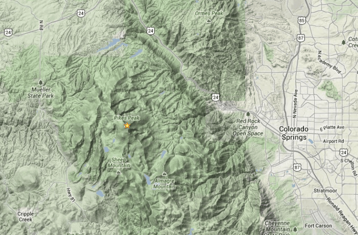
Perhaps this should be called The Slacker’s Guide to Activating Pikes Peak since I am going to describe the easy way to do a Summits On The Air (SOTA) activation on America’s Mountain. If you plan to hike up, you have my complete support but this post is not meant for you.
Pikes Peak (W0C/FR-004) is about 10 miles straight west of downtown Colorado Springs. See the Pikes Peak website for useful tourist information. At an elevation of 14,115 feet, the mountain towers over Colorado Springs and the other front-range cities. (You may see the elevation listed as 14,110 but it was revised upward in 2002 by the USGS.) This means that it has an excellent radio horizon to large populated areas. On VHF, it is possible to work stations in Kansas, Nebraska, Wyoming and New Mexico. See VHF Distance From Pikes Peak and Pikes Peak to Mt Sneffels. On HF, you’ll do even better.
Getting There
Access to the summit has three options: hike up, drive up via the Pikes Peak Highway or ride the Pikes Peak Cog Railway. Most people will probably choose the highway since the cog rail only gives you 30 to 40 minutes on the summit. (Normally, you return on the same train that takes you to the top. You can try to schedule two one-way trips but that is a challenge.)
After a few years of turmoil and construction, the summit of Pikes Peak is now back to operating normally but with some changes. The new summit house/visitors center is open and it is a beautiful new facility. The Cog Railway is also operational with brand new equipment. There is a new boardwalk that allows easy strolling on the summit and improved views near the edge of the summit.
Pikes Peak Highway
The highway is at a well-marked exit off Highway 24, west of Colorado Springs. There is a “toll” to use the highway (~$15 per person, check the Pikes Peak Highway website for the latest information and a $2 discount coupon.) Starting in 2022, you must have a reservation (2-hour window) to drive to the summit (roughly Memorial Day to Labor Day). The specifics are likely to change, so be sure to check the Drive Pikes Peak page for the latest updates.
The road is paved all of the way to the top and is usually in good shape. The only caution on driving up is that some people get freaked out by sections of the road that have steep drop-offs without guard rails. It is very safe, but some folks can’t handle it. The main caution driving down is to use low gear and stay off your brakes. There are plenty of signs reminding you to do this and during the summer there is a brake check station at Glen Cove where the rangers check the temperature of your brakes.
It takes about an hour to drive to the summit, assuming you don’t dawdle. It is best to drive up during the morning and avoid the afternoon thunderstorms.
On The Summit
The W0C Association Reference Manual (the SOTA rules for Colorado) used to suggest a “qualifying hike” of 100 vertical feet but this item has been removed from the manual. If you decide to do such a hike, I suggest you proceed down Barr Trail which is the main hiking trail coming up from the east side of the peak. Do not try to walk along the road, as the rangers will stop you. The trail starts on the east side of the summit house (towards Colorado Springs) and is marked with a sign. You have to cross over the cog rail tracks to get to it. (Please try to avoid getting run over by the train as it scares the tourists and makes a mess.)
The summit of Pikes is broad, flat and rocky, so pick out a spot away from the buildings for your SOTA adventure. There are quite a few radio transmitters on the peak so expect some interference. Since this is way above treeline, your antennas will have to be self-supporting. For VHF, giving a call on 146.52 MHz FM will usually get you a few contacts and sometimes a bit of a pileup. Be aware that on top of Pikes you are hearing everyone but they can’t always hear each other. It can get confusing. Another VHF simplex frequency worth trying is 146.58 MHz (The North America Adventure Frequency). On the HF bands, pray for good ionospheric conditions and do your normal SOTA thing.
Your body and your brain will likely be moving a little slower at 14,000 feet due to the lack of oxygen. Don’t be surprised if you have trouble deciphering and logging callsigns. Take it slow and monitor your physical condition on the peak.
Bring warm, layered clothes, even in the summer, since Pikes Peak can have arctic conditions any time of the year. Keep a close eye on the weather since thunderstorms are quite common during the summer months. Lightning is a very real danger, so abandon the peak before the storms arrive.
In May, we met up with our friends Paul/KF9EY and Beth/KB9DOU for a trip on the Blue Ridge Parkway. Joyce/K0JJW and I had been on the parkway before but had not completed the whole route. We all thought it would be a great trip to do together, in about a week, so we would not be in a rush. Both couples have Class B RVs (camper vans), which are well-suited for such a trip.
The Blue Ridge Parkway is part of the National Park Service, construction started in the 1930s and took decades to complete. The basic concept is a scenic road with a maximum speed limit of 45 MPH connecting Great Smoky Mountain National Park and Shenandoah National Park. We met at the Smoky Mountain end of the parkway and traveled north to Shenandoah.
Of course, we included some Summits On The Air (SOTA) and Parks On The Air (POTA) activations. The Blue Ridge area is target-rich with SOTA and POTA opportunities.
Clingmans Dome
Our first Summits On The Air (SOTA) activation was from Clingmans Dome (W4C/WM-001), the highest spot in the Great Smoky Mountain NP. This is an easy activation with a half-mile hike (one way) to an observation tower. See my previous trip report here.
We opted for a simple VHF SOTA activation, using a Yaesu FT-2DR handheld transceiver and an RH-770 whip antenna. The observation tower was not too crowded and we were able to make a surprising number of 2m FM radio contacts. We just called CQ on 146.52 and raised a number of home stations, mobile stations, and a few campers. Joyce, Paul, and I all completed at least 10 contacts so we decided to submit the activation for both POTA and SOTA.
Joyce/K0JJW makes 2m FM contacts from Clingmans Dome while Bob/K0NR stands by.
Blue Ridge Parkway
Then we headed up the parkway, stopping along the way for photo opportunities, a winery visit, lunch stops, and short hikes. We stayed at different campgrounds for three nights along the parkway. To activate the parkway for POTA (K-3378), we stopped at a picnic area for lunch and set up for 20m SSB. We used our typical POTA setup: Yaesu FT-991 driving an end-fed-halfwave antenna supported by a fishing pole.
Bob/K0NR making 20m SSB QSOs on the Blue Ridge Parkway. Note the two Class B RVs in the background.
The station worked well for us but it was a little slow completing contacts on 20m. A 20 AH Bioenno battery supplied the DC power for the FT-991 and we kept the RF output at around 50 watts. I used HAMRS on my Windows PC for logging and it worked well for me. (That logging program keeps getting better with each revision.) Paul and Joyce preferred to log using old-fashioned pen and paper.
Paul/KF9EY worked 20m POTA while Joyce/K0JJW does the logging.
Loft Mountain Campground
We camped the last two nights of our trip together at Loft Mountain Campground in Shenandoah NP. This is a rather unique spot in that the campground is located on top of a broad SOTA summit and is inside a national park. The SOTA summit is appropriately named Big Flat Mountain (W4V/BR-009), while Shenandoah NP is park K-0064. This makes for an easy SOTA plus POTA activation.
The summit is located inside the National Radio Quiet Zone, which may require you to coordinate with the NRQZ before operating. However, the W4V Association Reference Manual says that “the typical SOTA activation does not require coordination,” mainly because it is a short-term, temporary radio activity.
Once again, we operated midday on 20m SSB and had reasonably good propagation. Joyce and I made some stateside contacts but when Paul took over, he snagged a couple of European stations. That might be due to his superior operating skill or maybe the band just shifted. Between the three of us, we made 45 QSOs in about an hour or so.
Summary
We had a fun time on this trip, which is another example of blending SOTA and POTA activities with a camping vacation. Our “leisurely pace” strategy worked out well and we were never in a hurry. Of course, there are always more things we could have done. The Blue Ridge Parkway has plenty of interesting tourist, hiking, and SOTA/POTA opportunities. Too many to do in a week.
We have been looking for an opportunity to activate a SOTA summit in our home state of Indiana. Joyce/K0JJW and I were both born there and misspent our youth there. Of course, you might be thinking “there are SOTA summits in Indiana?” Yes, there are three. Two of them are on public land, one is on private land and apparently inaccessible. These three summits are in the southern part of the state, not too far from the hills of Kentucky.
We were headed south towards the Smoky Mountains and passing through southern Indiana and decided to activate Jackson County HP (W9/IN-002). First, we camped at one of Indiana’s best state parks: Brown County State Park, about an hour away from IN-002. The next day we headed to the Jackson-Washington State Forest, where the summit is located. The Indiana Dept of Natural Resources supplies this trail map. As you’ll see, there are a number of trails that can take you to IN-002, but we chose the most direct route, starting at Knob Lake.
There is a State Forest campground around Knob Lake, so that would be another option for camping out.
The red line shows our track up to the summit, starting from Knob Lake.
We headed up a gated road that was labeled “Trails 2 and 3”. This road narrowed into a trail and we took a left turn at the Trail 2 sign. This is slightly tricky because Trail 2 goes off to the left and it continues on straight. The “left” Trail 2 ascends up to IN-002, for a total elevation gain of 465 feet and a distance of 0.7 miles. Go Left.
Once on top, we unpacked our recently purchased Icom IC-705 transceiver. This seemed like a good choice for this activation. While we were sure to try good old 2m FM, there was a good chance that we would get skunked on VHF at this rural and not-too-high summit. Sure enough, 2m FM was silent, even using the mighty 3-element Yagi antenna.
Next, we set up the end-fed halfwave for 20 meters, hoisted by the popular extendable fishing pole. OK, I admit that I had to do some fiddling around with the antenna to get the SWR to behave. Somehow, the test run at the campsite the day before was not sufficient. The SWR was way too high for the “I like 50 ohms” Icom, so some adjustments were required. After an unreasonable amount of fiddling, we put out an SSB signal on 20 meters that seemed good.
The band conditions were not great but they were not terrible. Calling CQ did not seem to work very well, so we tuned around and worked a number of Parks On The Air (POTA) stations to get our 4 QSOs. At that point, we declared victory and headed back down the hill.
This summit was easy to access and an easy hike. If you are in the area and want to knock out a Hoosier SOTA activation, this one is a great choice.
When doing VHF activations for Summits On The Air (SOTA), the radio range is dependent on the height of the summit and the surrounding terrain. The Radio Mobile website from Roger/VE2DBE is a great tool that can be used to estimate the radio range from a particular site. Repeater system owners often use tools like this to predict the coverage of their repeaters. I don’t normally do this type of analysis for SOTA…I just look at a topo map and get a rough idea of how far my signal will go. Then, I decided to spend a little time analyzing a few summits in Colorado to see what I could learn.
Pikes Peak (W0C/FR-004)
Pikes is a 14,115-foot summit that towers over the eastern plains of Colorado, making it an ideal radio site. The Radio Mobile plot shown below shows the solid radio coverage in blue and the fringe area in yellow. I won’t go into how to use Radio Mobile on this post. As you’d expect, you enter the location of the radio site (summit) along with various parameters such as frequency, minimum detectable signal level, transmit power, and antenna gain. I entered some nominal parameters consistent with typical SOTA stations on 146 MHz (2 meters).
VHF coverage prediction for Pikes Peak (W0C/FR-004)
Pikes covers about half of the state of Colorado, reaching out to the Kansas state line. To the west, the coverage does not go as far because the radio signals are blocked by other mountain ranges. In particular, the signal tends to drop off at the Sawatch Range, west of Buena Vista. I’ve activated Pikes many times and this plot lines up well with my general experience. The blue area can be worked quite reliably with a decent station on both ends. By “decent” I mean a 20-watt transmitter on the summit with a small Yagi antenna and a 40-watt radio with an omnidirectional antenna at the chaser station. Working stations near the Kansas state line is usually easy on 2m FM. The highest spot in Kansas (Mount Sunflower, not a SOTA summit) can usually be worked without much trouble. However, longer distance contacts are possible, especially using SSB or CW. I’ve written before about the Myth of VHF Line-Of-Sight.
When using VHF for SOTA activations, it is important to consider the potential stations that will be within range and on the air for you to work. Besides being a high summit, Pikes overlooks the major cities in Colorado, from Fort Collins to Pueblo, so finding someone to work on 146.52 MHz is usually easy. It is common to have a pile up of stations calling you.
Colorado has over fifty 14,000-foot mountains and all those are workable from Pikes Peak on 2m FM.
Mt Herman (W0C/FR-063)
Mt Herman is another popular SOTA summit, with an elevation of 9063 feet, not nearly as high as Pikes Peak. This summit also looks out over the eastern plains of Colorado, as shown in the coverage plot below. Although the range is not as good as Pikes, it still covers the major cities, so again it is easy to do a 2m FM activation from Mt Herman. It is more difficult to work stations to the west. I can usually work stations in Woodland Park and Divide from Mt Herman, but reaching Buena Vista is a challenge.
VHF coverage prediction for Mount Herman (W0C/FR-063)
Threemile Mountain (W0C/SP-107)
VHF activations can be much more challenging when the summit is further away from populated areas. Let’s consider Threemile Mountain, which is 10,020 feet in elevation, located about 20 miles south of Hartsel, CO. This summit tends to get blocked to the east by the Front Range and to the west by the Sawatch Range. Even though the summit is higher than Mt Herman, its radio range is not as good.
VHF coverage prediction for Threemile Mountain (W0C/SP-107)
In particular, it does not cover Denver, Colorado Springs, and Pueblo very well, so the number of available stations to work drops dramatically. There are a number of hams that monitor 146.52 MHz up in the mountains, so if you are patient you can usually make some VHF contacts. This can be a source of frustration for VHF activators, or you can take it on as a challenge.
I have activated Threemile five times and I don’t think I’ve ever worked a Denver station on 2m FM. I have worked some Denver stations from there using 2m SSB, during a VHF contest. Oh, I did manage to work Larry/N0LL in Smith Center, KS on 2m SSB for a distance of 372 miles. See Radio Fun on Threemile Mountain (W0C/SP-107). So you never know what you’re going to get on VHF/UHF.
Conclusions
So what conclusions can we draw from this analysis?
Radio Mobile does a good job of predicting typical 2m FM coverage. My experience on these summits aligns well with the Radio Mobile predictions.
But much longer distance contacts are still possible. VHF is not limited to line of sight. Radio Mobile is intended to predict reliable radio coverage, not the exceptional radio contact.
Be aware of the population density of the coverage area because that is a huge factor for making radio contacts. New VHF activators should start on summits that overlook the major Colorado cities.
Improve your VHF activator station. Every additional dB of signal improves your ability to make those weak-signal contacts on the edge of the coverage area.
As always, get off the couch, gather your radio gear, and head for a summit.
In January 2021, I wrote about the North America Adventure Frequency (NAAF) which originated in the North America SOTA community. About a year later, how is this working out? Is anyone actually using it?
A few key points to remember:
The NAAF is 146.58 MHz.
This frequency is in addition to, not a replacement for, the National Simplex Calling Frequency 146.52 MHz.
Local usage will likely vary depending on needs.
Program 146.58 MHz as The Other Simplex Frequency in your radio.
I’ve noticed that quite a few SOTA activators are posting Alerts and Spots with 146.58 MHz. For example, K2CZH and KN6OUU posted these SOTA Alerts:
Here N8FN and WJ7WJ are spotted on 146.58:
Of course, the National 2m FM Calling Frequency (146.52 MHz) still gets a lot of use. I tend to use Five Two when I am activating in rural areas, some distance from the major cities. The frequency is usually quiet AND there are a number of folks that tend to monitor it. I use the NAAF when I’m near the big cities (Denver, Colorado Springs, Boulder, …). Putting out a Spot is usually important, to get the attention of the more dedicated SOTA chasers watching SOTAwatch. That is, I don’t think there are a lot of people monitoring the frequency (compared to 146.52), so a spot on SOTAwatch gets them on frequency.
Some of the Parks On The Air (POTA) activators are also using NAAF. Here’s an activation alert by KD7DTS from the POTA website:
So I think the NAAF is working as intended. It is not a replacement for 146.52 MHz but a standard choice for portable operating when you want to stay off the calling frequency. Thanks to everyone that has given it a try.
 My article that describes last year’s SOTA/POTA/VHF contest activation from Pikes Peak appears in the June issue of QST magazine. This VHF/UHF activation occurred on the Saturday of the ARRL June VHF Contest and qualified for Summits On The Air (W0C/FR-004 Pikes Peak) and Parks On The Air (K-4404 Pike National Forest). The article highlights the use of the North America Adventure Frequency of 146.58 MHz.


 We accessed Red Mountain 3 (RM3) by taking Highway 550 to Red Mountain Pass. The road for RM3 is County Road 14 but is not well marked. The turnoff (shown on the map above) is just south of Red Mtn Pass, going to the east (37.89587, -107.71369). County Road 14 is a narrow but easy road, barely 4WD, that leads to the gate (37.89476, -107.70774). We parked there and hiked up the road.