This year, the Colorado 14er Event had the normal two-day (Saturday and Sunday) schedule plus two bonus days (Friday and Monday) for four activation days. Of course, Joyce/K0JJW and I decided to activate all four days using VHF/UHF frequencies. Frankly, we have not been doing that much hiking this year, so we were careful to lay out a plan that would work for us over four days.
Kaufman Ridge (W0C/SP-081)
On Friday, we hiked up Kaufman Ridge, which is a relatively easy summit near our cabin. I had an online meeting in the morning that caused us to get a late start this day, but we did chase some activators in the morning. On the summit, we worked a number of stations on VHF/UHF using the IC-705 transceiver. It was clear that most of the activators left their summit before noon, as is the usual practice for the 14ers and high peaks.
Normally, we focus our SOTA fun on VHF/UHF but this time I brought along an end-fed halfwave antenna for 20m and made a few 20m SSB contacts, including one with Elliot/K6EL on Mount Davidson (W6/NC-423). That’s right, a rare HF SOTA activation by K0NR. Joyce and I also turned in a log for Parks On The Air (POTA), which was San Isabel National Forest (K-4407).
Bob/K0NR on the trail up Kaufman Ridge.
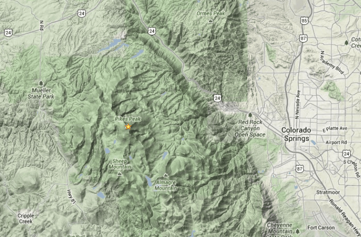
Pikes Peak (W0C/FR-004)
On Saturday, I wanted to focus on making some 1.2 GHz (23 cm) contacts so we chose Pikes Peak as a good platform for that. Pikes is always fun because of its easy access (yes, we drove up) and its high location towering over eastern Colorado. We had Jon/KM4PEH and his wife join us on the summit, taking turns using the VHF/UHF bands. I made 42 QSOs on the various bands but my 23 cm contact with N0OY was the most exciting. I worked him in Salina KS on 1296.1 MHz using CW for a distance of 627km (392 mi). This is my new personal best for SOTA on that band. See this post for more detail on this contact.
Saturday was a good day for Summit-to-Summit (S2S) radio contacts, as I picked up 13 of them, all on VHF/UHF in Colorado. Joyce and I both worked Dave/W0ADV on Capitol Peak (W0C/SR-060) using 1.2 GHz FM. Capitol is a challenging climb, as shown in Dave’s video here.
Pikes Peak is in the Pike National Forest (K-4404), so we submitted our logs for POTA.
Bob/K0NR sitting down on the job, getting ready for a 23 cm activation.
Mount Antero (W0C/SR-003)
On Sunday, we got up early and drove the Jeep up Mt Antero Road, parking at about 13,600 feet in elevation. This cuts a large chunk of the distance and elevation off the ascent to 14,268 feet. Besides, who wants to hike on a 4WD road anyway? It is still a decent climb over the rocky trail to get to the top.
A view of Mount Antero, on the way up.
This was my fourth SOTA activation of Antero, including its first activation back in 2011. (Actually, I’ve activated this many more times during the Colorado 14er Event, which predates SOTA in Colorado.) The activity was down a bit from Saturday and we were much further away from the large population centers, which is a factor on VHF/UHF. Still, we both made 17 QSOs, including five S2S contacts. We submitted our logs to POTA for San Isabel National Forest (K-4407).
Bob/K0NR working 2m FM from the summit of Mt Antero.The 70cm Yagi-Uda antenna is vertically polarized for FM operation.
Wander Ridge (W0C/SP-042)
On Monday, we activated one of our favorite summits near Cottonwood Pass, SP-042. Usually, I would refer to this as an Unnamed Summit (12,792), which is the name the SOTA database shows. Dave/W0ADV pointed out this summit does have a name: Wander Ridge, so I’ve adopted it for this special peak. The USGS approved that name in 2017 but it has not yet made it into the SOTA database.
Bob/K0NR on the Continental Divide Trail and Colorado Trail, headed to Wander Ridge.
From an outdoor hiking perspective, this was the best summit of the weekend. The hike starts at Cottonwood Pass and follows the Continental Divide Trail south toward the summit. Then, a short off-trail hike takes you to the summit. The weather and views were excellent!
Bob/K0NR and Joyce/K0JJW on the summit of Wander Ridge.
The activity was a bit light but we both made 10 contacts, enough to qualify for a POTA activation (in addition to SOTA). This summit is right on the border of San Isabel NF and Gunnison NF, and we chose to activate it from the San Isabel side (K-4407). We only had one S2S contact, with Steve/K5SJC on Pikes Peak.
All in all, it was a fantastic weekend with four excellent summit activations. It was wonderful to work our old and new SOTA friends on the VHF/UHF bands. My special thanks go to Pete/N0OY for firing up his mega 23cm station to work me on Pikes Peak.
Amateur Radio operators from around Colorado will be climbing many of Colorado’s 14,000-foot mountains and Summits On The Air (SOTA) peaks to set up amateur radio stations in an effort to communicate with other radio amateurs across the state and around the world. Join in on the fun during the annual event and see how many of the mountaintop stations you can contact. Be aware that many mountaintop activators will hit the trail early with the goal of being off the summits by noon due to lightning safety concerns.
This event is normally held the first full weekend in August. Following up on the success of the 10-day W0C SOTA event in 2021, in 2022 we will add two bonus days to the Colorado 14er Event. The main two days remain Saturday and Sunday (Aug 6 & 7), while the bonus days are Friday Aug 5 and Monday Aug 8th, for those SOTA enthusiasts that need more than two days of SOTA fun!
The 14er event includes Summits On the Air (SOTA) peaks, which includes over 1800 summits! If you aren’t up to climbing a 14er, there are many other summits to choose from (with a wide range of difficulty). See the W0C SOTA web page at w0c-sota.org.
Important: The recommended 2m FM frequencies have been changed to 146.58, 146.55, and 146.49 MHz, to align with the use of the North America Adventure Frequency for SOTA (146.58). The National Simplex Calling Frequency (146.52) may be used as appropriate. See the operating frequencies page.
Radio operators who plan to activate a summit should post their intent on the ham14er group via the ham14er groups.io website. Also, be sure to check out the event information at http://www.ham14er.org
For a complete list of suggested HF, VHF, and UHF frequencies see this web page.
And there is more!
On the same weekend, SOTA enthusiasts in Montana, Idaho, Washington, and Oregon will activate summits for the Pacific Northwest Not-Quite-Fourteener (PNW-NQF) event. Also on the same weekend, the Southern California SOTA group will hold their SOCAL SOTAFEST. So there will be plenty of SOTA stations to work that weekend.
Warning: Climbing mountains is inherently a dangerous activity.
Do not attempt this without proper training, equipment and preparation.
This post was updated on June 4, 2022, after the summit house construction was completed.
Perhaps this should be called The Slacker’s Guide to Activating Pikes Peak since I am going to describe the easy way to do a Summits On The Air (SOTA) activation on America’s Mountain. If you plan to hike up, you have my complete support but this post is not meant for you.
Pikes Peak (W0C/FR-004) is about 10 miles straight west of downtown Colorado Springs. See the Pikes Peak website for useful tourist information. At an elevation of 14,115 feet, the mountain towers over Colorado Springs and the other front-range cities. (You may see the elevation listed as 14,110 but it was revised upward in 2002 by the USGS.) This means that it has an excellent radio horizon to large populated areas. On VHF, it is possible to work stations in Kansas, Nebraska, Wyoming and New Mexico. See VHF Distance From Pikes Peak and Pikes Peak to Mt Sneffels. On HF, you’ll do even better.
Getting There
Access to the summit has three options: hike up, drive up via the Pikes Peak Highway or ride the Pikes Peak Cog Railway. Most people will probably choose the highway since the cog rail only gives you 30 to 40 minutes on the summit. (Normally, you return on the same train that takes you to the top. You can try to schedule two one-way trips but that is a challenge.)
After a few years of turmoil and construction, the summit of Pikes Peak is now back to operating normally but with some changes. The new summit house/visitors center is open and it is a beautiful new facility. The Cog Railway is also operational with brand new equipment. There is a new boardwalk that allows easy strolling on the summit and improved views near the edge of the summit.
Pikes Peak Highway
The highway is at a well-marked exit off Highway 24, west of Colorado Springs. There is a “toll” to use the highway (~$15 per person, check the Pikes Peak Highway website for the latest information and a $2 discount coupon.) Starting in 2022, you must have a reservation (2-hour window) to drive to the summit (roughly Memorial Day to Labor Day). The specifics are likely to change, so be sure to check the Drive Pikes Peak page for the latest updates.
The road is paved all of the way to the top and is usually in good shape. The only caution on driving up is that some people get freaked out by sections of the road that have steep drop-offs without guard rails. It is very safe, but some folks can’t handle it. The main caution driving down is to use low gear and stay off your brakes. There are plenty of signs reminding you to do this and during the summer there is a brake check station at Glen Cove where the rangers check the temperature of your brakes.
It takes about an hour to drive to the summit, assuming you don’t dawdle. It is best to drive up during the morning and avoid the afternoon thunderstorms.
On The Summit
The W0C Association Reference Manual (the SOTA rules for Colorado) used to suggest a “qualifying hike” of 100 vertical feet but this item has been removed from the manual. If you decide to do such a hike, I suggest you proceed down Barr Trail which is the main hiking trail coming up from the east side of the peak. Do not try to walk along the road, as the rangers will stop you. The trail starts on the east side of the summit house (towards Colorado Springs) and is marked with a sign. You have to cross over the cog rail tracks to get to it. (Please try to avoid getting run over by the train as it scares the tourists and makes a mess.)
The summit of Pikes is broad, flat and rocky, so pick out a spot away from the buildings for your SOTA adventure. There are quite a few radio transmitters on the peak so expect some interference. Since this is way above treeline, your antennas will have to be self-supporting. For VHF, giving a call on 146.52 MHz FM will usually get you a few contacts and sometimes a bit of a pileup. Be aware that on top of Pikes you are hearing everyone but they can’t always hear each other. It can get confusing. Another VHF simplex frequency worth trying is 146.58 MHz (The North America Adventure Frequency). On the HF bands, pray for good ionospheric conditions and do your normal SOTA thing.
Your body and your brain will likely be moving a little slower at 14,000 feet due to the lack of oxygen. Don’t be surprised if you have trouble deciphering and logging callsigns. Take it slow and monitor your physical condition on the peak.
Bring warm, layered clothes, even in the summer, since Pikes Peak can have arctic conditions any time of the year. Keep a close eye on the weather since thunderstorms are quite common during the summer months. Lightning is a very real danger, so abandon the peak before the storms arrive.
When doing VHF activations for Summits On The Air (SOTA), the radio range is dependent on the height of the summit and the surrounding terrain. The Radio Mobile website from Roger/VE2DBE is a great tool that can be used to estimate the radio range from a particular site. Repeater system owners often use tools like this to predict the coverage of their repeaters. I don’t normally do this type of analysis for SOTA…I just look at a topo map and get a rough idea of how far my signal will go. Then, I decided to spend a little time analyzing a few summits in Colorado to see what I could learn.
Pikes Peak (W0C/FR-004)
Pikes is a 14,115-foot summit that towers over the eastern plains of Colorado, making it an ideal radio site. The Radio Mobile plot shown below shows the solid radio coverage in blue and the fringe area in yellow. I won’t go into how to use Radio Mobile on this post. As you’d expect, you enter the location of the radio site (summit) along with various parameters such as frequency, minimum detectable signal level, transmit power, and antenna gain. I entered some nominal parameters consistent with typical SOTA stations on 146 MHz (2 meters).
VHF coverage prediction for Pikes Peak (W0C/FR-004)
Pikes covers about half of the state of Colorado, reaching out to the Kansas state line. To the west, the coverage does not go as far because the radio signals are blocked by other mountain ranges. In particular, the signal tends to drop off at the Sawatch Range, west of Buena Vista. I’ve activated Pikes many times and this plot lines up well with my general experience. The blue area can be worked quite reliably with a decent station on both ends. By “decent” I mean a 20-watt transmitter on the summit with a small Yagi antenna and a 40-watt radio with an omnidirectional antenna at the chaser station. Working stations near the Kansas state line is usually easy on 2m FM. The highest spot in Kansas (Mount Sunflower, not a SOTA summit) can usually be worked without much trouble. However, longer distance contacts are possible, especially using SSB or CW. I’ve written before about the Myth of VHF Line-Of-Sight.
When using VHF for SOTA activations, it is important to consider the potential stations that will be within range and on the air for you to work. Besides being a high summit, Pikes overlooks the major cities in Colorado, from Fort Collins to Pueblo, so finding someone to work on 146.52 MHz is usually easy. It is common to have a pile up of stations calling you.
Colorado has over fifty 14,000-foot mountains and all those are workable from Pikes Peak on 2m FM.
Mt Herman (W0C/FR-063)
Mt Herman is another popular SOTA summit, with an elevation of 9063 feet, not nearly as high as Pikes Peak. This summit also looks out over the eastern plains of Colorado, as shown in the coverage plot below. Although the range is not as good as Pikes, it still covers the major cities, so again it is easy to do a 2m FM activation from Mt Herman. It is more difficult to work stations to the west. I can usually work stations in Woodland Park and Divide from Mt Herman, but reaching Buena Vista is a challenge.
VHF coverage prediction for Mount Herman (W0C/FR-063)
Threemile Mountain (W0C/SP-107)
VHF activations can be much more challenging when the summit is further away from populated areas. Let’s consider Threemile Mountain, which is 10,020 feet in elevation, located about 20 miles south of Hartsel, CO. This summit tends to get blocked to the east by the Front Range and to the west by the Sawatch Range. Even though the summit is higher than Mt Herman, its radio range is not as good.
VHF coverage prediction for Threemile Mountain (W0C/SP-107)
In particular, it does not cover Denver, Colorado Springs, and Pueblo very well, so the number of available stations to work drops dramatically. There are a number of hams that monitor 146.52 MHz up in the mountains, so if you are patient you can usually make some VHF contacts. This can be a source of frustration for VHF activators, or you can take it on as a challenge.
I have activated Threemile five times and I don’t think I’ve ever worked a Denver station on 2m FM. I have worked some Denver stations from there using 2m SSB, during a VHF contest. Oh, I did manage to work Larry/N0LL in Smith Center, KS on 2m SSB for a distance of 372 miles. See Radio Fun on Threemile Mountain (W0C/SP-107). So you never know what you’re going to get on VHF/UHF.
Conclusions
So what conclusions can we draw from this analysis?
Radio Mobile does a good job of predicting typical 2m FM coverage. My experience on these summits aligns well with the Radio Mobile predictions.
But much longer distance contacts are still possible. VHF is not limited to line of sight. Radio Mobile is intended to predict reliable radio coverage, not the exceptional radio contact.
Be aware of the population density of the coverage area because that is a huge factor for making radio contacts. New VHF activators should start on summits that overlook the major Colorado cities.
Improve your VHF activator station. Every additional dB of signal improves your ability to make those weak-signal contacts on the edge of the coverage area.
As always, get off the couch, gather your radio gear, and head for a summit.
Adam/K6ARK recently posted this video of his 2m SOTA activation in California. Adam does a really nice job with his videos and this one is no exception. During this activation, he worked KE9AJ in Arizona at 256 miles. This was an FM QSO, with KE9AJ running 6 watts and K6ARK running over 120 watts.
In the video, he shows the 8-element 2m Yagi antenna, which has a clever folding boom design (homebrew, I assume). You’ll notice that he is carrying quite a bit of gear in his pack, including a 160w amplifier, a Yaesu FT-857, several batteries, the Yagi antenna, and antenna masts. Adam has posted other videos of VHF SOTA activity, so check out his YouTube channel for them.
Note that at 256 miles, this is definitely propagation beyond line of sight. We’ve talked about this before: The Myth of VHF Line-Of-Sight.
This has me thinking about some of my best VHF SOTA activations, which I will list here.
Sneffels to Pikes
In 2012, for the Colorado 14er Event, Joyce/K0JJW and I climbed Mt Sneffels (W0C/UR-001) at 14,150 feet in elevation. I worked Stu/W0STU on Pikes Peak (W0C/FR-004). We both were running 5 watts on 2m FM, with 3-element Arrow II antennas. I had an FT-817, while Stu used an HT. We made the QSO without too much difficulty, at a distance of 160 miles. Stu put together this video that shows the action on both summits.
Capulin Mountain
Capulin Mountain (W5N/SG-009) is out in the middle of nowhere New Mexico, a long distance from populated areas. My goal was to activate it (and get the points) on VHF, but I knew it would be a challenge. I put the word out to the weak-signal VHF community and used my FT-817 (5 watts) and 3-element Yagi to make contacts. My best DX was with Arne/N7KA at 184 miles. I could hear him fine on SSB but he could not copy me, so we switched to CW to complete the QSO. Arne used a 2M12 Yagi antenna with 700 watts of power vs my 5 watts.
This turned out to be a good lesson in what happens when the two stations are imbalanced with respect to RF power. My 5 watts vs his 700 watts is a difference of 21 dB. No wonder I could hear him just fine but he was struggling to copy me. Flipping over to CW narrows the receiver bandwidth, improving the signal-to-noise ratio, and was enough improvement to make the QSO.
Mount Scott (W5O/WI-002) is a drive-up summit (elevation 2464 feet) in the Witchita Mountains of Oklahoma. It sticks up high enough to have a good radio horizon in all directions. We stopped there to do an activation in March 2018, using the Yaesu FT-90 (set for 30 to 50 watts) and the 3-element Yagi antenna.
We easily worked a bunch of stations on 146.52 MHz FM, including K5RTN in Brownfield, TX. Later, I checked the distance to Brownfield and found that it was 245 miles, which is still my best SOTA DX on 2m FM. There was probably some favorable propagation that morning, perhaps some ducting, for this to occur. K5RTN was operating from home and I am not sure about his power and antenna.
Threemile Mountain
During the 2021 January VHF Contest, we decided to activate Threemile Mountain (W0C/SP-107), which is usually accessible, even in the winter months. Because it is in the Pike National Forest (K-4404), I did a combo operation of SOTA, POTA, and VHF contest. At 10,020 feet in elevation, it is not the highest summit in the region but it has a good radio horizon in all directions.
Also, the hike is relatively short, so I packed the Yaesu FT-991 and a 20 Ah battery, which gave me more power (50 watts) on 2m and 70 cm. Not only that, I actually fired it up below 50 MHz and made some HF contacts, using single-band end-fed halfwave antennas.
I was working a few stations in Denver on 2m SSB when I heard Larry/N0LL calling me from Smith Center, KS. Larry is a well-known Big Gun on VHF with excellent antennas. I’ve worked him in past contests on various bands and modes but I was surprised how strong he was coming in at Threemile Mountain. We probably had favorable conditions on 2 meters that day but nothing exotic, to make a 372 mile QSO. I’ve worked longer distances on 2 meters but this is my best DX for SOTA.
Most ham transceivers have decent receivers, so the choice of radio on the receive side is not that critical. (OK, you can add a preamp in front of the receiver to improve it.) The big difference for making QSOs (or not) on 2 meters is antenna and power level.
Improving your antenna is normally the first step in improving your VHF SOTA station, because it helps on both transmit and receive. Joyce/K0JJW and I almost always use the 3-element handheld Yagi from Arrow Antenna. Arrow does not specify the gain, but various sources have measured it at 6 dBd. We have made many QSOs over the years where the extra 6 dB made the difference. An omnidirectional antenna would have come up short. I’ve been looking for a higher gain antenna to use for SOTA but have not found one that I like. Adam’s 8-element antenna is tempting but longer antennas pretty much require a mast, which adds weight to the pack. One of the benefits of the 3-element Arrow is that it is handheld, so we don’t carry a mast. Of course, having two of us activating together really helps…one person can hold the antenna while the other operates and logs. A handheld antenna with a single operator can be a challenge.
Concerning power level, the Capulin QSO with N7KA illustrates what happens when two stations are imbalanced with respect to RF power. After this experience, I did purchase a small 2m amplifier that boosts the 5 watts from the FT-817 to 35 watts. It is compact and not too much of a DC power hog. I think we also heard an imbalance with the QSO between K6ARK and KE9AJ. KE9AJ’s signal was a bit noisy at K6ARK while K6ARK’s signal was full quieting 59 at the other end. This is not a surprise with K6ARK at around 120 watts and K6ARK at 6 watts (13 dB difference).
For higher power on 2 meters, you generally need to bring a bigger radio or an amplifier. The popular HT is generally limited to about 5 watts. For 2m FM, we’ve been carrying the Yaesu FT-90, which is a pretty compact radio and can put out 50 watts of RF power (FM only). On the Threemile Mountain activation mentioned above, we took the FT-991, which is not very SOTA friendly, but it also does 50 watts on 2 meters…and all modes.
Battery capacity also comes into play as higher power requires more DC current. The FT-90 manual says it draws 9.5 amps at full 50 watts of power on 2 meters. (We usually run it at lower power but will punch it up to 50 watts when required.) The FT-991 manual says it draws 15 amps when transmitting at full power on 2m or 70cm. My 160 watt 2m (Mirage) amplifier can draw up to 30 amps on transmit. Wowzy, that’s some real current! The point is that as you increase power, you need to look at your battery situation more carefully.
It might sound like I am suggesting that we should maintain a power balance between the two stations. That’s not the case and is often not even practical. When one station is much stronger than the other, it can be used to advantage. The stronger station is easily heard and the weaker station can point the antenna in the right direction to peak up the signal. The weaker station consistently hears the stronger station, so now the challenge becomes to just get a few seconds of successful transmission in the opposite direction. You keep trying until the weaker station manages to get through. Compare this to having two lower power stations trying to make a contact. They may not even hear each other at all because the antennas are not pointed optimally. When they do hear each other, they are both struggling to hear the other station and complete the QSO. This lowers the probability of completing the contact.
So how much power should you run on 2 meters for SOTA? Of course, More Is Better, except for the extra weight in your backpack. The difficulty of the hike comes into play…on shorter hikes, weight does not matter so much. I am finding that 5 watts is on the skimpy side. On the other hand, going much above 50 watts requires larger batteries, so I am thinking the sweet spot is around 30 to 50 watts. If I do happen to work a base station running 1kW, my signal will be 13 dB lower with 50 watts (worst-case scenario). This is just my opinion, your mileage may vary.
Summary
So can we all agree then that VHF signals can go beyond line-of-sight? These examples are basic tropospheric paths and do not include the exotic propagation modes such as meteor scatter, sporadic-e, aurora, EME, etc. I’ve used most of those modes to work longer distances but not during a SOTA activation. Most hams know that SSB and CW are more effective than FM when signals are weak. In fact, FM weak-signal performance is lousy. Still, we see multiple examples of making some long-distance contacts with FM.
Visiting Yellowstone and Grand Teton National Parks is a favorite trip for us. It is a 9-hour drive to get there from Colorado, so we can make it in a day. In September, we visited these two parks with a blend of activities in mind: RV camping, hiking, viewing wildlife and ham radio. The ham radio part means Summits On The Air (SOTA) and Parks On The Air (POTA).
The Teton mountains tower above the Snake River.
Our trip started from Monument, CO, followed by a stop at our cabin near Trout Creek Pass. Heading north, we spent one night at Steamboat Lake State Park (Colorado), which broke up the road trip into smaller sections.
A few of the many buffalo (bison) in Yellowstone National Park.
Grand Teton NP
Grand Teton NP listed 27 activations for POTA (POTA K-0031) which is really not that many activations for such a well-known national park. The park and the surrounding national forests have many SOTA summits available, some quite difficult to climb (such as 13,770 foot Grand Teton). We camped two nights at Colter Bay RV Park, inside the park. This is a decent RV-style campground with full hookups and campsites packed in a bit tight.
Joyce/K0JJW campsite operating POTA from the Grand Teton campsite.
Our usual POTA station is the Yaesu FT-991 driving a single-band end-fed halfwave (usually 40m, 20m or 17m) supported by a fishing pole and powered by a 20 Ah Bioenno battery. Joyce/K0JJW likes to use a paper log but I usually log my contacts with HAMRS, either on my notebook PC or an iPad. HAMRS is a relatively new logging program that runs on most operating systems (Windows, Mac, Linux, iOS, Android, etc.) It is tuned for portable operating, with templates for SOTA and POTA. Check it out, if you haven’t tried it.
One unfortunate surprise while operating from the campsite was a ton of RFI coming from the electronic devices in use by the herd of RVs. The noise floor on 20m was S5— not so good. It seems that today’s RV enthusiast brings along complete wireless network support with internet access points, WiFi routers, and their associated Part 15 emissions. Oh, well.
After setting up on 20m SSB, K0JJW and I both completed 10 QSOs with some difficulty. We were clearly being heard but we had trouble digging signals out of the noise.
Next up was a VHF SOTA activation on Signal Mountain (W7Y/TT-161). This is an easy-to-access drive-up summit with a great view, highly recommended with or without a SOTA activation. We debated on whether to use HF for SOTA on this trip. Normally, we’ve stuck to VHF/UHF on SOTA summits, as part of the Height-Above-Average-Terrain experience. However, knowing that Northwest Wyoming is a bit sparse for VHF activity, we could easily get skunked on a SOTA activation (less than 4 QSOs). Despite that, we opted to stick with VHF for SOTA and focus on a successful activation (1 QSO or more), with or without the SOTA points. On Signal Mountain, we worked two stations on 2m FM, including Steven/KB7ITU in Rexburg, ID, about 60 miles away. (Hey, we worked another state on VHF!)
Speaking of VHF, we used our dualband mobile (IC-2730A) to listen to the national park repeaters while we travelled through the park. Our dual-receive radio always has 146.52 MHz on one side and “something else” on the other side. When inside large national parks, we’ll set the second receiver to a national park frequency. These are generally conventional FM in the 162 to 173 MHz range. I won’t list the Teton and Yellowstone frequencies here but you can find them with a little searching on the interwebz. For example, see wiki.radioreference.com for Yellowstone NP frequencies.
Yellowstone National Park
Yellowstone ( POTA K-0070 ) had only 22 POTA activations, not that many considering it is the nation’s first national park. It also has quite a number of SOTA summits of varying difficulty.
We camped two nights at Grant Village campground, a basic national park campground. The campground had no hookups but the campsites are well spaced with many trees and flush toilets. (The only problem we had was when the park service booked another group of campers onto our campsite one night.)
Joyce and our RV (Rocky Victoria) at the Grant Village campsite.
During a previous visit to Yellowstone, we activated Lake Butte (W7Y/PA-219). On this trip, we had our eye on Mount Washburn (W7Y/PA-163), a well-known 10k summit and popular hike, but the road that provides access to it was closed for the summer due to construction. (OK, maybe next time.)
Bob/K0NR operates 2m FM from the unnamed summit W7Y/TT-139.
Instead, we decided to try an unnamed summit 8770 (W7Y/TT-139) that was relatively easy to access but had not been activated for SOTA. We found some trip reports that said there is a nice trail to the summit and the only complaint was that the summit does not have a view due to the many trees. We parked at the Divide Trailhead, about 12 miles west of Grant Village. The trail is 1.8 miles in length (one way) with 700 feet of elevation gain. So not too difficult but a real hike. The summit is broad and sure enough with lots of trees, so no view. Practice normal bear precautions on this trail.
Practice standard bear precautions in this area.
Again, we opted for VHF SOTA, knowing that we might not get enough radio contacts for points…but we only needed one contact to qualify as the first activation. We worked two mobile stations passing through the park on 146.52 MHz. Yes, it is good to always be monitoring the calling frequency. You never know who is going to show up.
For POTA, we noted that the Continental Divide Trail National Scenic Trail (K-4558) passes through Yellowstone NP, which would allow for a double activation. The CDT has always been special to me as it passes through Colorado and provides some of the most scenic hiking in the state. It only had 15 activations listed at that time, two of those were ours from when we activated it a month earlier, in Colorado. We choose the Old Faithful area as a good place to activate Yellowstone NP ( K-0070) and the CDT. We set up near the edge of the parking lot, away from the crowds. Again it was the FT-991 driving the endfed halfwave on 20m SSB. It was midday, so we expected good 20m propagation (and a nice pileup for Yellowstone) but the band was not cooperating. We both made at least 10 QSOs for a successful activation, so we count that as a win, but the pileup never happened.
Besides the radio operating, we had a good time touring through the park and looking for wildlife. We saw tons of buffalo, not quite so many elk and deer, but no bears or wolves. We have had better wildlife viewing on previous trips but it was still fun.
Heading South
Then it was time to start home, heading south out of Yellowstone back through Grand Teton. Of course, we were monitoring 146.52 MHz, when we heard Lorene/KG6MWQ on unnamed summit 7586 (W7Y/TT-164). She was on the summit with AE6NH, operating both HF and VHF. It was great to catch a VHF activator in Yellowstone. This was the first activation for TT-164, so congratulations to both of them.
Two POTA activators smiling for the camera (Joyce/K0JJW, Bob/K0NR).
We decided to make a stop at the Colter Village area on the way through Grand Teton NP. Our first priority was to use the shower facilities there. Our second priority was doing another POTA activation.
Yaesu FT-991 set up on small camp table, with microphone and two sets of headphones.
This time we set up in a large parking lot, away from anything that might produce RFI. Again, it was 20m SSB using the halfwave antenna supported by a fishing pole. We sat near the RV on our camp chairs and table. Our typical configuration is to have two sets of headphones so both of us can copy well. We just use the standard handheld microphone which is easily passed between us when we change operators.
Typical antenna setup with fishing pole inserted into a plastic pipe attached to the RV ladder. A wire antenna is hung from the end of the pole.
Later in the day, we exited the park and headed south through Jackson, WY. We stayed overnight at a farm near Afton, WY which is surrounded by Bridger-Teton National Forest (K-4535). Of course, we needed to do one more POTA activation. We searched around for a usable spot to park and then fired up on 20m SSB. Propagation was OK but not great but we got it done.
The next day, we were up and going early, driving the rest of the way home to Monument. It was a wonderful road trip that blended sightseeing, hiking, camping, and ham radio. Let’s go do it again!
Joyce/K0JJW climbing London Mountain, with Mosquito Peak in the background (right).
We had a great time going after the W0C 10-10-10 SOTA Challenge. (See 2021 Colorado SOTA and 14er Event ) For activators, the objective was to activate 10 summits higher than 10k feet in 10 days. It turned out that some previous commitments would not allow us to do 10 days of activating, so we smushed 10 summits into 6 days. With careful choice of summits and doing multiple summits in a day, we put together a plan.
Bob/K0NR and Joyce/K0JJW on Puma Peak.
Saturday and Sunday started off with the Colorado 14er Event, so we opted to do Pikes Peak on Saturday and Mount Evans on Sunday. These are both drive-up summits, so not a lot of hiking. As previously reported, we had some good luck with 1.2 GHz from those summits. Then, on Monday we hiked Puma Peak and Little Puma, two 11k summits in South Park. On Tuesday, we did three summits on one day: Dicks Peak, 10090 and 10715. These three hikes were not particularly difficult but doing all three made for a full day.
Map of the ten summits that were activated.
On Wednesday, we took the Jeep up to Mosquito Pass and hiked two 13ers: Mosquito Peak and London Mountain. We had previously activated those two summits in 2018. Finally, on Thursday, we did our tenth summit with Walt/W0CP and Jerry/K0ES, one of our favorites: South Monarch Ridge. Walt and Jerry worked the HF bands while we did VHF/UHF. That was a slacker day, because we rode the tram up from Monarch Pass.
Bob/K0NR standing next to the Jeep with Mosquito Peak in the background.
The weather was consistently fantastic, with no thunderstorms in sight. The smoke from western wildfires was thick at times and can be seen in some of the photos.
The Bands
As usual, we operated above 50 MHz, focusing on 2m, 70cm and 23cm FM operation. Most of the contacts were on 2m FM but we had significant activity on the other bands. The 1.2 GHz work was really fun: Using 1.2 GHz in the Colorado 14er Event. I made 162 contacts and Joyce made 94, for a total of 256 for the week. Not bad!
Six activators met the challenge of doing at least 10 summits during the event. That was our goal…not pursuing the top of the list but we did want to get 10 summits done. I am fifth on the list and K0JJW came in at sixth. We had the same number of SOTA points because we did the same summits. I had more QSOs though.
It was a fun event and we were happy to be able to activate 10 summits. Fortunately, the weather was good, otherwise we might have gotten rained out on the longer days.
Last weekend we held the Colorado 14er Event (Aug 7 and 8), the annual mountaintop event in Colorado. A group of us used this weekend as an opportunity to make 1.2 GHz (23 cm) Summits On The Air (SOTA) contacts: K0NR, K0JJW, KM4PEH, K5RHD, W0ADV, KL7IZW, W0RW, KC5RW, and K0BEJ.
The Alinco DJ-G7T
Many of the 1.2 GHz operators used the Alinco DJ-G7T triband handheld transceiver. This radio covers the 2m, 70cm and 23cm bands. The RF output on 23 cm is only 1 watt but it is the lowest-cost way of getting a signal on that band.
Pikes to Uncompahgre
On Saturday, Joyce/K0JJW and I were on Pikes Peak (W0C/FR-004) and worked Randy/K5RHD on Mount Evans (W0C/FR-003) at a distance of 97 km (60 miles). Signals were strong and we had no problem making those contacts.
We also worked David/W0ADV on Uncompahgre Peak (W0C/RG-001) at a distance of 227 km (141 miles). David used the Alinco HT driving a 16-element Comet Yagi. We had a bit more power (10 watts) from our Kenwood TM-541A transceiver, also driving a Comet Yagi antenna. Signals were strong in both directions and these QSOs were a new personal best for both Joyce and me on 1.2 GHz.
Evans to Sunshine
On Sunday, we moved to Mount Evans and Randy/K5RHD activated Pikes Peak. We worked Randy on that peak, the reverse of the QSO on the previous day. Meanwhile, David/W0ADV was climbing two 14ers in the San Juan Mountains: Redcloud Peak (W0C/RG-002) and Sunshine Peak (W0C/RG-004). These two summits are close to each other, separated by a saddle, so it is common to climb them as a pair.
David/W0ADV aims his 16-element Yagi on Sunshine Peak.
David’s route had him climbing Redcloud first and then continuing on to Sunshine, then returning to Redcloud on the way back down. We worked him on Sunshine and on the return trip over Redcloud, as he headed back to the trailhead.
Map of the radio contact between Sunshine Peak and Mount Evans.
We had trouble hearing David on Sunshine Peak but his signal was just strong enough that we could complete the contact. His signal was stronger from Redcloud, a surprise because the two summits are close in elevation. I expected them to be about the same in terms of signal path and strength. David reported that there was a ridge to the northeast of Sunshine that might be blocking the signal, but it was not in the way for Redcloud.
So these contacts with Sunshine Peak set a new personal best for both Joyce and me on 1.2 GHz (244 km, 152.6 miles). David clearly did the hard work, summiting two 14ers in a day. (We were on a drive-up mountain with a short hike.) Thanks, David/W0ADV!
I was very pleased with the results from the 14er weekend. Now I am wondering what’s next for us concerning 1.2 GHz. We can probably make radio contacts further out but it is going to depend on the topography of the path. We will have to do some investigation on additional summits to try.
The Summits On The Air (SOTA) program originated in the United Kingdom but has propagated to most countries around the world. The program came to Colorado on May 1st, 2010 with Steve/WGØAT sending a CQ from Mount Herman, just west of Monument. Today, the SOTA program in Colorado (called WØC-SOTA) is very active with roughly 180 activators that operate from Colorado summits.
To celebrate our 10th Anniversary, WØC-SOTAis organizing a 10-10-10 Event with a challenge for Activators and Chasers alike. (Activators operate from summits, Chasers try to contact them.)
Activator challenge: Activate 10 (or more) 10K feet (or higher) summits (in Colorado/WØC) within 10days.
Chaser challenge: Chase Activators on 10 different (or more) qualifying WØC summits (10K or higher) within the 10 days.
Event Date: We will kick-off the event in conjunction with the Colorado 14er event on August 7th, 2021 and conclude on August 16th.
Everybody is invited to participate, either as an Activator or a Chaser. Block off these days in your calendar now and start planning for how you can participate. Feel free to operate as much or as little as you would like. It is all about having fun messing around with radios. Any HF, VHF or UHF band can be used for making SOTA contacts, with the most popular ones being 40m (CW & SSB), 20m (CW & SSB) and 2m (FM).
Steve/WG0AT operating from the summit of Mount Herman (W0C/FR-063)
Note that the recommended 2m FM frequencies for the 14er event have changed to:
146.580 FM North America Adventure Frequency
146.550 FM Simplex Alternate
146.490 FM Simplex Alternate
146.520 FM National 2m FM Calling Frequency
(as needed, please don’t hog the calling frequency)
There will be a leaderboard on the W0C-SOTA website showing all participants who meet one of the challenges. More details will be announced on the WØC-SOTA Website as soon as they are hashed out.
Lately, for the ARRL January VHF contest, I try to find a SOTA summit to activate. Operating time is usually just a few hours, so it does not make for a big score. The main advantage is for VHF SOTA (Summits On The Air) because there is a lot more activity on 2m CW and SSB. This year, I wanted to go for the mountaintop trifecta of SOTA, POTA (Parks On The Air) and VHF contest in one activation.
Threemile Mountain is an easy SOTA summit: easy to access via forest service roads and an easy hike.Joyce/K0JJW operating the portable station on 2m FM.
Threemile Mountain (W0C/SP-107) emerged as the activation summit because it is not too far from our cabin and accessible in the winter. (This time of year, the roads to many of our favorite summits are blocked.) For POTA, it is located in the Pike National Forest (K-4404). Because it is a short hike, I concluded that I could carry the Yaesu FT-911 and the 20 Ah Bionno battery. This would cover all the bands, give us more RF punch and still have plenty of battery capacity.
The portable station with 100 watts on HF, 50 watts on 2m/70 cm.
I carried quite a collection of antennas which gave us plenty of operating choices. We started out on 2m and 70 cm FM, working mostly local stations. This quickly got us enough contacts for SOTA and POTA points. We used a rollup J-pole for 2 meters and 70 cm, until it became intermittent and the SWR went wild. Then we switched to the Arrow 3-element Yagi for 2 meters.
Bob/K0NR operating from Threemile Mountain.
About that time, I decided to see what was happening on 2m SSB. There were a number of contest stations on the air, mostly from the front range cities (Denver, Boulder, Colorado Springs, …). I worked a bunch of them using 50 watts from the FT-991 to the 2m Yagi antenna (horizontally polarized).
The QSO between K0NR on Threemile Mountain (DM78) and Larry/N0LL near Smith Center, Kansas (EM09).
Suddenly, I was surprised to hear N0LL from Kansas calling me. I’ve worked Larry before from Colorado but it usually was from a really good location such as Mt Herman or Pikes Peak. Even then, we often had to switch to CW to complete the contact. Today he was louder than many of the Denver stations. We easily worked on SSB, which turned out to be a new personal best DX for me from a SOTA summit (372 miles).
We deployed both the SOTA and POTA flags today.
After things slowed down on 2m SSB, I decided to make some HF contacts. The North American QSO Party (SSB) was active, so I decided to set up for 20m and see who I could work. Running 100 watts to an endfed halfwave kept me competitive with the contest stations. Then I moved up to 17m SSB and worked non-contest POTA and SOTA chasers.
Bob/K0NR and Joyce/K0JJW hanging out on the summit of Threemile Mountain.
We both accomplished the three-in-one mountaintop activation for SOTA, POTA, and the VHF contest. I also worked the NA QSO Party, so that makes it four-in-one, but who is counting? The January weather cooperated with us with almost no wind on the summit, about 28 degrees F. We sat there in the sunshine and just enjoyed the view before hiking back down.
Charlie/NJ7V invited Joyce/K0JJW and me to be on the All Portable Discussion Zone, on the Red Summit RF YouTube channel. We talked mostly about Summits On The AIr (SOTA) using VHF/UHF. It was a fun experience for both of us.
For Summits On The Air activations, I have been exclusively using the VHF/UHF spectrum. I like the HF bands but for SOTA, I just think that Height Above Average Terrain (HAAT) of a summit is an ideal match for frequencies above 50 MHz. See Summits On The Air VHF Mountain Goat.
Threemile Mountain, viewed from the east.
After much naggingpeer pressure encouragement from my fellow W0C SOTA activators, I decided to give HF a try. (The solar index had markedly increased in the past week, so the timing seemed right.) I chose an easy summit to hike (Threemile Mountain), so I could just focus on the radio operating. Plus, Joyce/K0JJW and I were carrying a bit more radio gear, the usual VHF station plus my Yaesu FT-817 for the HF bands. For HF antennas, I dug up two single-band EndFedz halfwave antennas for 20m and 15m from the basement. I’ve used these for portable HF work in the past and they have performed well.
The summit was an easy hike, as expected. Once on top, we quickly made four contacts on 2m FM and then set up the HF station. I used a telescoping fishing pole as the antenna support, strapped to a conveniently-located pine tree. The halfwave antennas were mostly horizontal and not that far off the ground (maybe 15 feet at the highest point).
This SOTA activation was on Halloween, so we chose costumes that blended in with the wildlife (Joyce/K0JJW, Bob/K0NR).
A quick check of the SWR using the internal FT-817 meter showed that the transmitter was happy. Then, I called Bob/W0BV on 14.346 MHz to see if I was radiating anything. I was not real strong at his location but we made the contact just fine. As soon as he spotted me on SOTAwatch, I had a nice pileup of stations calling. In the meantime, Joyce kept working stations on 2m FM.
The FT-817 transceiver operating on 20m powered by Bioenno battery (not shown).
I quickly made 12 QSOs on 20m, including F4WBN in France (best DX for the day). Before I left 20m, Bob/W0BV met me on 14.061 for a CW contact. Just because. Then, I took the 20m antenna down and hoisted the 15m halfwave, the same configuration but a bit shorter in length. The 15m band was not quite as good and had more fading but I made 7 QSOs there.
Map of K0NR SOTA contacts from Threemile Mountain.
I was very pleased with the results, especially being able to use 15 meters, my favorite HF band. I could have brought along additional antennas to try 17m, 12m and 10m, but there’s always next time. I had a great time working the SOTA chasers on HF, so I will surely do it again.
One thing to watch out for when doing SOTA activations is the presence of strong Radio Frequency Interference (RFI) on some peaks. The typical scenario is that the summit is also an established radio site with transmitters that interfere with your ham radio operations.
Bob/K0NR checking out the radio gear on Mount Bailey (W0C/FR-062).
I use the VHF/UHF bands for SOTA, so I am writing from that perspective. My impression is that HF interference is much less likely because these radio sites don’t usually have any HF transmitters. However, they may have broadband noise sources such as networking equipment, power line arcing or switching power supplies that can create problems on HF. Anyway, this post is focused on 2 meters and higher bands.
In my experience, the transmitters at radio sites may include land mobile repeaters (VHF or UHF), NOAA Weather (162.xx MHz), TV/FM broadcast stations and mobile wireless (cellular) systems. The TV/FM broad stations are really bad news because they run a crapton of RF power.
The worst summit I have encountered is Sandia Crest (W5N/SI-001) near Albuquerque, NM. See trip report here. They even have a sign in the parking lot to warn you that the RFI may wipe out your car’s keyless remote.
Well, this sign did warn me of radio interference at Sandia Crest.
In a high RFI environment, your radio receiver gets overloaded such that you can’t hear stations calling you but they can hear you just fine. This results in the SOTA activator calling and calling while the chasers get frustrated that the activator never hears their call. Not good. It may not be obvious that this is happening. This blocking of the receiver may come and go, depending on which transmitters happen to be active.
Mitigation Strategies
There are a few things that you can do to deal with the RFI:
Move Away From The Source
Probably the first thing to try is just moving away from the source of interference. This may mean moving away from the highest point on the summit but it may be better overall to give up a few feet of elevation to not have the interference. You’ll need to stay in the activation zone to be a legitimate SOTA activation.
Use A Better Radio
Some radios are better than others when it comes to receiver performance including the ability to reject unwanted signals. The low cost radios from China (Baofeng or similar) generally have lousy receivers so they are a poor choice for operating from an RFI-intense summit. Many people report better results with the Yaesu FT-60, a solid performer. Commerical radios from Motorola are even more robust. I’ve been using a small mobile radio for SOTA (Yaesu FT-90) which outperforms most handheld radios.
Change Your Antenna
Using a directional antenna can help…just point it away from the source of the interference. Oddly enough, using a worse performing antenna can help improve your ability to communicate. For example, a rubber duck antenna on a handheld radio will allow less of the interfering signal to get into your receiver which may improve your ability to receive. As long as the antenna is “good enough” to complete the radio contact, it may be the way to go. One trick I’ve used is to deploy two radios, one for receive with a crummy antenna and the other for transmit with a better antenna. That way, you still radiate a stronger signal while reducing the interference into the receiver.
Use A Bandpass Filter
You can insert a filter into your antenna feedline to reduce the interfering signal. The best approach is to use a bandpass filter that passes the frequency you are operating on but attenuates other signals. SOTABeams offers a compact bandpass filter for the 2m band. (Note that it has a 5W power rating which is fine for handheld radios but not more powerful transceivers.) DCI Digital Communications offers higher power filters but they are much larger in size.
Change Frequency
Sometimes a small change in frequency might help a bit if the interference is limited to certain frequencies. Another tip is to try another band. That is, if you are getting interference on 2 meters, you may find that the 70 cm band is better. Or vice versa. It all depends on the transmitters at the site.
Congratulations to my wonderful spouse and favorite hiking partner, Joyce/K0JJW, for achieving Mountain Goat status for Summits On The Air (SOTA).
Joyce/K0JJW on Pikes Peak, working a pileup as she qualifies for Mountain Goat.
On August 10th, she reached 1000 activator points while activating Pikes Peak (W0C/FR-004). She had quite the pileup on 146.55 MHz. Her best DX for the day was WY7ATH near Cheyenne, WY at a distance of 167 miles. Not bad!
Early on, she always hiked with me on SOTA activations but didn’t start pursuing activator points until the middle of 2017. All of her SOTA contacts have been on the VHF/UHF bands, lots of 2m FM along with 2m SSB, 70 cm and 23 cm FM.
Joyce has activated 181 summits, 112 unique in 19 associations.
She is the second female Mountain Goat in Colorado (after Lynn/KC0YQF) and is the eighth female goat in North America.
McQuaid Butte (W0C/SP-019) is a 9043-foot mountain near our cabin in Park County. Joyce/K0JJW and I activated it for Summits On The Air (SOTA) way back in 2013 but for some reason, we had not been back to it. The access road (Salt Creek Road, FS 435) is gated closed from January 1 to June 15 to protect wildlife habitat, so I suppose that is a factor.
McQuaid Butte (W0C/SP-109) as viewed from the south.
Today, we decided to make a return trip to the summit and activate it on VHF/UHF. I remembered that Salt Creek Road can turn into a muddy mess but today it was dry and easily drivable with most vehicles. Salt Creek Road is accessed from Highway 285, south of Fairplay but north of Antero Junction.
Access to McQuaid Butte is via Salt Creek Road, from Highway 285. The hiking route is shown in blue.
There is a good parking spot shown on the map above at 38.95791, -106.00790. A trail begins here, heading east. It used to be 4WD road but it is now closed to motor vehicles. This trail/road heads east and then curves to the north and eventually disappears. About that time, you’ll encounter a fence that needs to be crossed as you make your way towards the summit (approaching from the west). There are pieces of a trail here and there but its mostly bushwacking up the side of the summit. In places, there is substantial downed timber that can be stepped over and around but its mildly annoying.
Bob/K0NR relaxing on the summit.
Our route turned out to be 1.3 miles one way with 650 vertical feet. We both quickly made enough QSOs to qualify for activator points, working W0BV, KD0MRC, K0MGL, WZ0N on 2m FM (and some on 70 cm). The weather was excellent, resulting in a fun SOTA activation in the Pike National Forest.
We will probably return again to this summit because it’s a nice hike that is easy to get to from our cabin. It would also be a great choice for someone passing through on Highways 24 or 285.
73 Bob K0NR
Updated 06 July 2024:
We have been back to McQuaid Butte again and have refined the route a bit. As time has passed, the trail is starting to take shape, at least part of the way. The route is not that critical but these notes may make it just a little bit easier.Follow the old road, now a trail, from the parking location. It will curve around to the north and pretty much fade out. At this point, you should see the fence line that runs roughly east/west. Follow this fence line, walking on the south side. At some point, you need to jump the fence. There is a noticeable path on the other side of the fence which indicates where most people crossover. Keep walking along the fence line (on the north side), following the worn path that later turns north. The trail is very established here and easy to follow. Later it fades a bit but you should be able to follow it. Leave the trail somewhere around the marked waypoint (McQuaid – leave trail, 38.96536, -106.00255). Hike off-trail to the summit..it will get steeper and there is downed timber but not too bad.
In 2018, Joyce/K0JJW and I did a trip to the Black Hills area of South Dakota to do some SOTA activations: Dakota SOTA Adventure. We really enjoyed that part of South Dakota and figured we would be back. The Black Hills top out at ~7200 feet and the climbs are usually interesting but not very difficult. There are plenty of SOTA summits to choose from and the scenery is beautiful.
Bob/K0NR and Joyce/K0JJW standing in front of their RV (Winnebago Paseo). Photo: K0DAJ
This summer we found ourselves on a road trip returning to Colorado from Wisconsin, so we decided to swing by South Dakota for a couple of days. Joyce is getting close to achieving the coveted SOTA Mountain Goat award (1000 activator points), so we were looking to add to her activator score. I’m not saying we only did easy summits but we pretty much did easy summits.
Looking at the SOTA database, we scanned for summits with 6 points or higher that also had a significant number of activations. On this trip, we were driving our Class B RV (basically a big honkin’ van with RV gear in it). This limited our choice of SOTA summits to ones that can be accessed via reasonably good roads. We were fine with the typical gravel US Forest Service road in good condition but not anything worse.
We connected up with Don/K0DAJ who we met at a hamfest in Loveland, CO earlier this year. Don reviewed my list of potential summits and provided valuable feedback and additional summit suggestions. Don also alerted the local hams that might want to get on the air to work us. We use VHF/UHF exclusively for SOTA, so it is easy to get skunked if there isn’t anyone around. (I found out later that Gary/KT0A also passed along the word for us.)
The SOTA Summits
We identified seven summits that we wanted to activate, which would provide 56 new activator points. They ended up being clumped into three northern summits, around Deadwood, and four southern summits southwest of Rapid City. We camped at a USFS campground in between the two clumps, activating the northern three on the first day and the southern summits on the second day.
A map showing our seven SOTA summits in the Black Hills area.
Terry Peak (W0D/NW-002)
Terry Peak is a drive-up mountain with a short hike up to an observation platform. We approached Terry Peak from the south on Terry Summit Road, off of Hwy 85/Hwy 14A. The Black Hills National Forest map is very helpful for finding all of these summits.
We discovered that Terry Peak is quite the tourist spot and several groups of people showed up while we were there. It is also a big radio site with over a dozen towers and many more transmitters. When we parked, I noticed that the VHF/UHF mobile transceiver in the RV had both S meters pegged at full scale on all frequencies. Rut Roh, there is probably some RF around here. As usual, we had the Yaesu FT-90 transceiver which has a robust receiver in it, and it performed well. Still, I noticed that strong signals would abruptly drop down to being almost unreadable when some transmitter on the site turned on.
Bob/K0NR operating 2m FM on Terry Peak, using the Arrow 3-element Yagi antenna.
Mount Theodore Roosevelt (W0D/NW-023)
Mount Theodore Roosevelt turned out to be a pleasant surprise with a really good trail to the summit (0.4 miles one way, less than 200 feet elevation gain).
The trail as it just leaves the parking lot area.
Also, at the summit, there is a tower that was built in honor of President Roosevelt. This is a fun little hike with a monument at the summit.
We climbed the stairs leading to the top of the tower and operated from inside it. The tower reminds me of the many lighthouses we’ve been inside, but it’s not nearly as tall, and no light.
Bob/K0NR working 2m FM from inside the tower.
Unnamed Summit – 5110 (W0D/NW-038)
For a third summit, Don suggested an easy-to-access unnamed summit (5110), W0D/NW-038. We got there by driving south from Sturgis on Vanocker Canyon Road (26), then west on Galena Road to USFS 171.1. Driving a short distance north on 171.1 got us to an open area where we parked. Then it was just a bushwack up the hill (no trail), 0.3 miles one way with an elevation gain of 400 feet.
Location map of W0D/NW-038. The blue line is the hiking path that we took to the summit.
Second Day
Day 2 was a repeat of summits that we did in 2018, so I won’t repeat all of that here: Odakota Mountain (W0D/BB-002), Bear Mountain (W0D/BB-029), Coolidge Mountain (W0D/BB-012) and Rankin Ridge (BB-089). Refer to the 2018 trip report for more info.
This time, Odakota Mountain was extra special because Don/K0DAJ joined us on the summit.
Don/K0DAJ and Bob/K0NR at the parking spot for Odakota Mountain.
There is an actual summit marker for Odakota, so I had to get a photo of me standing there.
Bob/K0NR standing at the Odakota Mountain High Point marker.
Most of the contacts were on 146.52 MHz, a few on 446.0 MHz. Joyce’s log and my log are pretty much the same but I did work a few more stations. In summary, we had QSOs with these stations during the two days: AD0HL, K0DAJ, KB0QDG, KC0WC, KD0AYN, KF0AFX, KF0ARA, KF0XO, KF7ZQL, NC0K, W0LFB, W0NIL, W0SEB, W0SSB, W5LJM, W7LFB, WN6QJN and WS0V. Thank you to each and every one of you for getting on the air!
In Colorado, we pretty much work Colorado stations on VHF from the summits, so it was fun to contact other states on this trip. From Bear Mountain, we worked W0NIL and W0SSB in Chadron, NE, about 90 miles away. Not too shabby. From Terry Peak, we worked Clem/KF7ZQL in Carlile, WY at a distance of 50 miles. Not as far, but another state in the log.
We caught AD0HL and KF0ARA on unnamed summit 6167 (W0D/BB-008) from both Odakota Mountain and Bear Mountain, for two Summit-to-Summit (S2S) contacts. We also got two S2S contacts with Don/K0DAJ: Crooks Tower from Terry Peak and Terry Peak from Mount Theodore Roosevelt. It was kind of an S2S festival!
Don/K0DAJ and Terry/AD0HL worked us on 6 of the 7 summits, so they were our most prolific chasers. Thanks, guys! Finally, special thanks to Don for the helpful advice and joining us to play radio in the Black Hills.
We were able to get our minimum 4 QSOs on each summit and usually had many more. This resulted in 56 activator points, so we are quite happy with that. We have just sampled a few of the many SOTA summits in the Black Hills area, so I suspect that we will be back for more.
Amateur Radio operators from around Colorado will be climbing many of Colorado’s 14,000-foot mountains and Summits On The Air (SOTA) peaks to set up amateur radio stations in an effort to communicate with other radio amateurs across the state and around the world. Join in on the fun during the 29th annual event and see how many of the mountaintop stations you can contact. The covers the entire weekend but many mountaintop activators will hit the trail early with the goal of being off the summits by noon due to lightning safety concerns.
The event includes all Summits On the Air (SOTA) summits, which adds over 1800 potential summits! If you aren’t up to climbing a 14er, there are many other summits to choose from with a wide range of difficulty. See the Colorado SOTA web page at w0c-sota.org
Radio operators who plan to activate a summit should post their intent on the ham14er group via the ham14er groups.io website. Also, be sure to check out the event information at http://www.ham14er.org
Frequencies used during the event Activity can occur on any amateur band including HF and VHF. The 2m fm band plan uses a “primary frequency and move up” approach. The 2m fm primary frequency is 147.42 MHz. At the beginning of the event, operators should try calling on 147.42 MHz. As activity increases on that frequency, move on up the band using the 30 kHz steps. Don’t just hang out on 147.42 MHz…move up! The next standard simplex frequency up from 147.42 MHz is 147.45 MHz, followed by 147.48 and 147.51 MHz.
For a complete list of suggested HF, VHF and UHF frequencies see this web page.
Warning: Climbing mountains is inherently a dangerous activity.
Do not attempt this without proper training, equipment and preparation.
There is a lot more information available here: www.ham14er.org
Sponsored by The Colorado 14er Event Task Force
Also be aware that the SOCAL SOTAFEST is happening on the same weekend, which means there will be plenty of SOTA activity on the ham bands! See http://socalsota.com
Way back in 2013, Joyce/K0JJW and I did the first SOTA activation of W0C/SP-099, an unnamed summit in the San Isabel National Forest. As is often the case, we just reviewed the forest service map and drove down a road that got us sort of close to the summit and headed on up. On this initial activation, we came from the south, which is a viable route, but not all that great. Later, Walt/W0CP found a much better starting point to the east of the unnamed summit, so we were interested in trying that out.
The driving directions are to take County Road 187 south to CR 185, then turn off onto 185E. Consult the San Isabel National Forest map for context. The graphic below shows the immediate area near the summit.
The blue line shows the hiking route to SP-099.
The only mildly tricky part of FS 185E is that it passes through a section of private property that is surrounded by national forest. There are a number of private drives along the road (most of them gated and labeled “No Trespassing.”) However, 185E keeps on going and pops out the other side, where a wire gate marks the reentry into the national forest. Walt indicates a good place to park is at Lat/Lon 38.78067, -105.98301. The road was in good condition and should be passable with a high-clearance 2WD vehicle.
At this point, headed west towards the summit, hiking off trail. There is very little downed timber so the walk is quite enjoyable. The specific route is not critical but stay north of the private property.
Typical terrain and vegetation heading towards the summit.
My GPS app shows the hike at 0.85 miles one way with 460 feet of elevation gain. This is easy peasy, so we have started to call this unnamed summit “EZ 99”.
Joyce/K0JJW hiking near the summit.
We worked a number of stations on 2m FM and then headed on down. (We also activated Bald Mountain W0C/SP-115, about two miles west, on the same day.)
This summit is now on our highly recommended list, an easy-to-access, pleasant hike in a beautiful area of Colorado.
While looking for our next SOTA adventure, I noticed a never-been-activated, unnamed 13er (W0C/SP-020) to the west of Mount Princeton. I checked various maps and it looked like there was a 4WD forest service road that went up to the adjacent saddle. So Joyce/K0JJW and I decided to give it a try.
SP-020 as viewed from the saddle (and parking spot).
We took County Road 306 west out of Buena Vista, towards Cottonwood Pass. Then we turned left onto County Road 344 which goes to Cottonwood Lake. We continued past Cottonwood Lake until we found FS 348, also known as Hope Gulch Road. We followed this road for 5 miles to the saddle.
This graphic shows the 4WD road in red and the hiking route in purple.
The road was easy-peasy 4WD, no problem at all with our stock Jeep Wrangler. A Suburu-class SUV can probably make it but there are a few rocky spots on the road that will require special care. There were two water crossings, one of them with about a foot of water (across Cottonwood Creek). Now this was mid-October, so the streams are not running real strong. Earlier in the year, this could be a major hazard.
Warning: water crossing at Cottonwood Creek.
A closeup view of the hiking path (0.6 miles, 800 feet vertical)
FS 348 is single lane, with long stretches without an easy passing or turnaround spot. We were happy that we only saw two other vehicles on the road.
Talus
We drove a bit past the saddle (where there is a small hut/cabin) and parked where a closed side road heads off toward the summit. We hiked up this closed road and then vectored off towards the summit. The hike was only 0.6 miles and 800 vertical feet. However, there was quite a bit of talus (rock debris) to climb over which really slowed us down. The hiking route does not seem critical but following the top of the ridge seemed to be good.
Near the top, we encountered lots of talus.
Yeah, about the talus. It isn’t any worse than other rocky summits in Colorado but it seemed to catch our attention, usually in the form of “ok, I’ve just about had it with this talus.” A contributing factor was that both Joyce and I had foot/ankle injuries in recent years. So our unofficial name for this summit became Talus.
Joyce/K0JJW on the summit of W0C/SP-020A pile of gear at the summit.
Joyce/K0JJW took the honors of completing the first SOTA activation of this summit by contacting Bob/W0BV on 2m FM. We also both logged these stations: KD0MRC, W0RW, W6JM, W0LSD and N0AJN.
Bob/K0NR operating 2m from the summit, wearing orange during hunting season.
We sat there quite a while just taking in the view. Mt Princeton is due east; Mt Antero and Mt White are to the south.
The view of Mt Princeton, five miles east of SP-020.
You never know what your gonna get on the first activation of a summit. On this one, it turned out to be a fantastic day. The weather was sunny, temperature about 40 degrees, a little too windy at times. Late in the season, we didn’t have to worry about thunderstorms moving in and blowing us off the mountain. I liked the combination of a good 4WD road, heart-pumping but not-too-difficult hike, a first-time SOTA activation and doing it all with my favorite hiking partner (and wife).
SP-089 has a large rock face on the south/southwest side, so it is best to approach from the other side.
Back in 2014, Joyce/K0JJW and I did the first activation of W0C/SP-089 (also known by its elevation: 10525). See the trip report here.
As noted in that trip report, we never did find much of a trail so we had to do some serious offtrail bushwacking. Being on the summit was great but bushwacking up was not. Later Walt/W0CP found a much better route using the Davis Meadow Trail. We definitely wanted to try this route and get back on top of that summit.
This overview of the area shows the route we took up SP-089 in blue and the Davis Meadow Trail as shown on the Trails Illustrated map.
We approached the Davis Meadow Trailhead from the east via Highways 285 / 24. We took FS 311 from Trout Creek Pass to FS 373, then FS 373A. FS 311 starts out in good condition, passable by high clearance 2WD vehicles. Later it turns into “easy 4WD” but it gets very steep in spots which may be a problem during wet weather. You can also approach from the west side coming up from Buena Vista. Check the San Isabel National Forest map for the complete picture.
Just to the east of the unnamed summit is a natural arch, marked on some maps as Aspen Arch. We’ve hiked up the arch on numerous occasions, often with visitors from out of state. So we’ve started referring to this unnamed SOTA as Aspen Arch, to differentiate it from the other unnamed summits in the area.
SOTA summit W0C/SP-089 is also known by its elevation (10525). A nearby landmark is Aspen Arch.
The Davis Meadow Trailhead is marked by a sign. Trail 1413 heads north and loops around the north side of SP-089. The trail is well laid out with plenty of switchbacks, much more than indicated on the Trails Illustrated map.
The blue line shows our actual hiking route as tracked by my GPS app.
We followed the trail until it looped around the north side of SP-089. Marmot Peak, another SOTA summit (W0C/SP-063), sticks out prominently to the north and is a good landmark to use for navigating. As shown on the map above, we left the trail and bushwacked south up to the summit. I don’t claim that our route was optimal. It was classic offtrail hiking with some areas quite open and others clogged with plenty of downed trees and rocks. (Next time, I think we’ll try to stay a little further east of our recorded track. It looked a little better over there.) Expect to be slowed down during this stretch.
Joyce/K0JJW on the well-established Davis Meadow Trail.
The GPS app on my phone recorded the one-way hike as 2.7 miles and 1100 vertical feet.
This was typical of the downed timber on the bushwack portion of the hike.
We arrrived at the summit around noon and thunderstorms were moving into the area. We both made four quick radio contacts on 2m FM to get the activation points, then headed back down the trail. The summit is exposed and very rocky but once we got off the top, we were hiking in trees with limited lightning danger. Thanks to Bob/W0BV, Jim/KD0MRC, Larry/KL7GLK and Kevin/KD0VHD for working us.
After our first bushwack adventure on this summit, we were not motived to activate this one again. However, using the Davis Meadow Trail has changed our opinion. (Thanks Walt/W0CP!) This route still has some offtrail bushwacking but it is not bad. We will be back!