It was a nice fall day, so Joyce K0JJW and I decided to go for an easy hike up Kaufman Ridge HP (W0C/SP-081) and do some SOTA operating. Well, maybe the hike was her idea and the Summits On The Air thing was my contribution to the plan. The hike is less than a mile with about 900 feet of elevation gain, depending on where you start.
This was definitely a slacker operation: easy access, easy hike, great weather and 2m FM activation via a handheld radio and the 1/2-wave whip.

Note that there are two SOTA peaks with the “Kaufman Ridge” name: Kaufman Ridge North (W0C/SP-085) and Kaufman Ridge HP (W0C/SP-081), located near Trout Creek Pass in Colorado. Today we headed to SP-081 which we reached by following County Road 318 from Trout Creek Pass, which is also called Buckrake Drive and then Windmill Drive. These roads pass through private property to reach the San Isabel National Forest, where there is a gate that is closed from December to April (see map). At this point, the road is easy 4WD; most 2WD high clearance vehicles will do fine. You can also approach from the south on FS 308 through Mushroom Gulch. 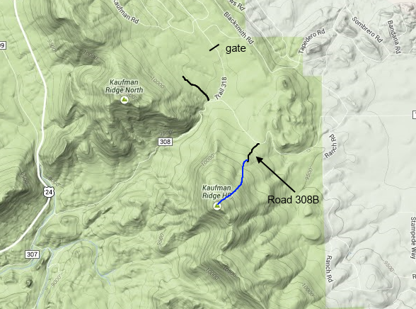
We turned left onto FS 308 and then took a short side road FS 308B toward the summit. There are several other turn offs but 308B seems the best (shown in black on map). The road is blocked for vehicular traffic at 38.858659° N / 105.933921°W. You can continue walking on the road a ways or just head straight for the summit (blue on map). While the hike is short and not very steep, there are plenty of downed logs to give you a challenge.
You never know who is going to show up on 146.52 MHz in the mountains but I had put the word out via email to some of the local hams to let them know I was doing a SOTA activation. When I got to the summit, I had a few stations already calling me and I quickly worked Ron N0MQJ, Jerry N0VXE, Dave K0HTX, Jim KD0MRC, Bob W0BV and Don K0DRJ. Don was my “best DX”, about 60 miles away in Woodland Park with a few mountains in the way. Thanks to everyone that came on frequency and contacted me.
Side note: if you want to activate SP-085, go north on a forest service road (shown in black on the map) near where 318 and 308 intersect. Just drive a short ways north, find a parking spot and bushwack your way up the summit. (NM5S provides some tips on finding a trail.) You could easily activate both summits in one day.
See this post concerning winter access to SP-085.
73, Bob K0NR
Update May 7, 2017
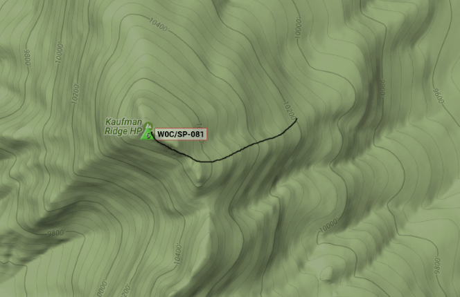
We’ve been up this summit several times now and have some additional info on hiking it. Note that the SOTA database now refers to SP-081 as simply Kaufman Ridge (dropping the HP or High Point designation). Also SP-085 is now called North Kaufman Ridge (instead of Kaufman Ridge North).
The directions for Kaufman Ridge are still valid, taking FS308B until it is blocked to vehicle traffic. We’ve found that approaching the summit a bit from the east is easier and more scenic. Overall, Kaufman Ridge runs NW/SE, so we try to do is intersect the ridge at a point on the SE side of the summit and follow the ridge on up. This avoids the large aspen grove directly NE of the summit, which has lots of downed timber to step over.
To do this, follow the closed-to-vehicles logging road to its end point. Then start off-trail hiking to the south, aiming for a point about a quarter mile southeast of the summit. There is no trail but for the most part you can hike through areas that are clear of timber. You will still encounter an aspen grove just below the ridge but it is scenic and easy to walk through. You should break through to the ridge shortly after that and get an amazing view of the Collegiate Peaks as you finish the journey.
Please let me know when you activate a new peak in the Buena Vista area. Thanks, Gary F. N0AJN
Gary,
I’ve added you to my list of “usual suspects” in the BV area.
73, Bob